Is There a Change Coming for Drought Stricken Areas?
Meteorologist Dr. Kevin Levey examines the drought conditions across the country.
Thursday, 01 March 2018 08:00:00 -06:00
Finally, signs of a pattern change and rainfall returning to parched areas of the country.
Some very welcome rains have returned to Central California, where some areas have gone without rainfall for 31 days. Too much of a good thing can be bad also as officials fear flooding near the burn areas of the Thomas Fire in Santa Barbara County, site of January's devastating mudslides. Heavy rains over the Ohio valley also triggered river flooding in that region. Figure 1 below shows rainfall over the country between 1 st and 22 nd February.
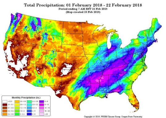
It’s the tale of west versus the east – too little in California where it is severely needed, and too much from northeastern Texas into the Ohio Valley. White on the map indicates ZERO rainfall, and unfortunately, much of California has been bone dry for well over a month. However, places from northern Louisiana, northern Mississippi, Tennessee, and parts of northern Indiana have had excessive rainfall with totals approaching 16” in places. Figure 2 below, shows the percentage of normal for the same period.
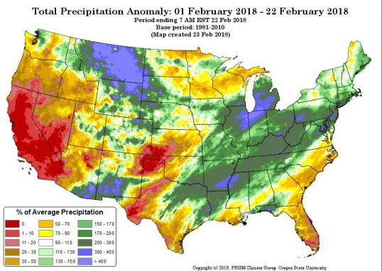
As expected, most of California and southern Nevada and western and far northern Texas are in the red – between 0 and 10% or normal rainfall. While much of the southern Mississippi Valley stretching northwestwards into southern New England has had well over 200% of normal. Florida has also not seen much rain this month, with most areas receiving < 50% of normal.
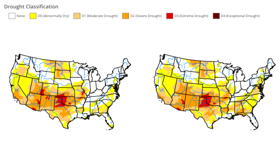
How has all this rain over the south and southeastern parts of the country affected the drought there? A quick look at the current drought situation over the United States shows the drought relief week over week is apparent in Figure 3 below which shows the current drought status over the United States compared to just 2 weeks ago. As of February 20 th, about 69% of the country was in an “abnormally” dry state, which marks an 8% decrease, most notably over the southeast and Gulf States. There has been a slight increase in severe or extreme drought (most notably over western and northern Texas and western Oklahoma) over the last two weeks. Severe drought has also increased its footprint over southern California, rising from 6% two weeks ago to 20% this week and currently 92% of the state is experiencing abnormally dry conditions, compared with 82% 2 weeks ago and 44% at the start of 2018. Welcome rains are expected to make a return to almost all of California later this week, with longer-term outlooks favoring a wetter than average March over California. Will it be a “Miracle March”? We shall see. At least the pattern is progressive with rain in the forecast.
Are you prepared for the next disaster?
Disasters can strike at a moment’s notice. That’s why, at ContactRelief, we provide round the clock disaster monitoring to keep your operations ahead of disasters. With timely, comprehensive recommendations that are accurate to the ZIP code, ContactRelief ensures you focus less on the disaster, and more on your operations.
Contact sales@contactrelief.com for more information.