Hurricane Florence Approaches North Carolina Coast
Historic rainfall, floods, widespread power outages expected
Thursday, 13 September 2018 08:50:00 -05:00
ContactRelief Recommendations for Contact Centers
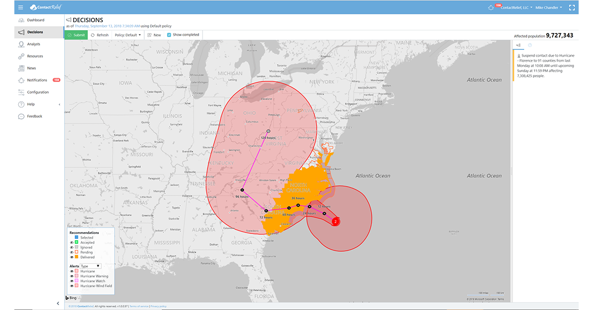
ContactRelief is making public recommendations first made to subscribers on Thursday, September 13th, 2018. ContactRelief recommends suspending contact with (or continuing suspension of contact with) parts of South Carolina, North Carolina, and Virginia due to the impending landfall of Hurricane Florence
ContactRelief recommends resuming contact with residents in the Hawaiian Islands, Guam, and the Northern Mariana Islands.
The National Hurricane Center has lowered the likelihood that a disturbance in the Gulf of Mexico will develop further into a tropical depression or storm. ContactRelief recommends normal contact operations for residents along the Texas coast.
To obtain the list of affected ZIP Codes, become a ContactRelief subscriber today.
Hurricane Florence
As expected, Hurricane Florence weakened as it approached the North Carolina coast. Florence is now a Category 2 hurricane with 110 mph winds. At 8 AM EDT (1200 UTC), the center of the eye of Florence was located by an Air Force Reserve reconnaissance aircraft and NOAA Doppler weather radars to be near latitude 33.1 North, longitude 75.1 West. The National Hurricane Center reports that Florence is moving slower toward the northwest at about 12 mph (20 km/h).
Although a weaker storm in terms of intensity, the size of the wind field, the area around the storm containing hurricane force and tropical storm force winds has grown. Hurricane force winds now extend approximately 80 miles for the center of the storm, and tropical force winds extend 195 miles from the center making Hurricane Florence a large hurricane. Still, the weaker intensity will mean less wind-related damage than would occur in a Category 4 storm but this may be small comfort for residents of North and South Carolina.
Squally rain bands with tropical force winds are moving onshore of the outer banks of North Carolina now. Life-threatening storm surge and rainfall is expected with conditions deteriorating significantly this afternoon. Hurricane force winds will impact North and South Carolina around midnight tonight and last for 12 to 20 hours. Tropical force winds will blow through the end of Saturday.
Major storm surge-related flooding is expected from the central coastline of North Carolina to Myrtle Beach, South Carolina through the late Friday or early Saturday morning. Storm surge related flooding is also possible further north in coastal inlets. Rainfall on coast of 24-30 inches is forecast with rain-related flooding along the coastline and up to 50-60 miles inland highly likely.
After an initial landfall or a close approach near Wilmington, North Carolina, the storm is expected to track to the south-west parallel to the coastline before eventually moving inland. The longer the storm drifts south close the coastline, the weaker it will become. However, this slow drift will mean that the high winds have more time to cause significant damage. Widespread and long-term power outages are expected.
Tropical Storm Olivia
Hurricane Olivia moved through the Hawaiian islands yesterday. Damage was minor. All tropical storm watches and warnings have been lifted.
ContactRelief is monitoring the storms
The ContactRelief Disaster Decision Team will continue to monitor the development of these storms and issue additional advisories as warranted.
With ContactRelief's Disaster Decision Engine, your company can avoid disasters by shaping the customer experience.
Schedule Your Product Demo Now!
Don't Delay
The next disaster is on its way. Become a ContactRelief subscriber and keep your company protected from disaster. Our full recommendations consist of the areas to be suspended and the list of zip codes covering these areas. With minimal effort, your company can quickly implement a solution that protects your company and its customers. As we say at ContactRelief, "It's just smart business."
Contact sales@contactrelief.com for more information.
Protect your brand AND revenue when disaster strikes.
Try ContactRelief FREE for 30 days. Discover how we can help you reach up to 5x more customers in a disaster zone – while protecting your brand image.
Start free trial