All Quiet on the Hurricane Front
Meteorologist Dr. Kevin Levey assesses the very quiet Atlantic hurricane season
Tuesday, 31 July 2018 05:30:00 -05:00
Tropical Outlook:
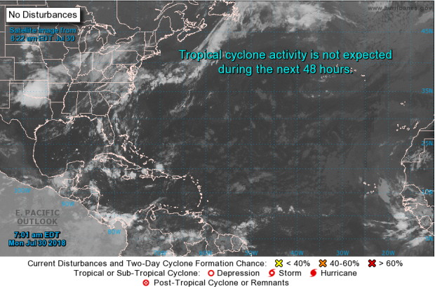
Conditions remain quiet throughout the Gulf of Mexico and the tropical Atlantic as a whole this morning as we approach the third month of the hurricane season, with no tropical systems currently active throughout the Western Hemisphere (as seen in Figure 1). The Gulf Coast is experiencing mostly sunny skies and warm temperatures this morning, with only some isolated thunderstorm activity present across the eastern half of the coastline.
Looking ahead towards to the next seven days, another quiet week is expected, with no tropical systems forecast to form in or enter the Gulf of Mexico. The Atlantic Ocean as a whole is expected to remain quiet as well, with no tropical cyclone formation expected to occur over the next seven days.
A quiet Atlantic hurricane season this July
July has been uncharacteristically quiet as far as Atlantic tropical systems are concerned. Not a single system to talk about since the 15th after Tropical Storm Beryl dissipated quietly off the coast of Newfoundland, Canada. The question here is why it has been so quiet? There are four main reasons:
- Cool sea surface temperatures (SSTs);
- High levels of African dust/dry air;
- An unfavorable phase of the Madden-Julian Oscillation;
- High wind shear has also contributed.
Let’s take a look at these reasons in more detail.
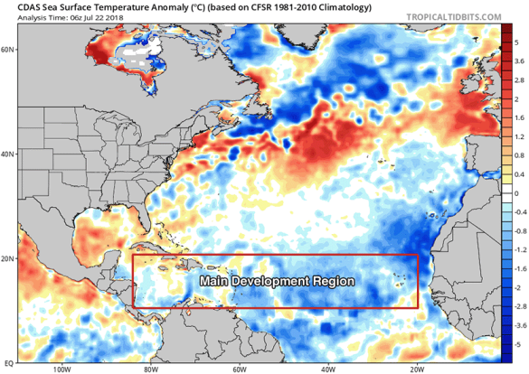
High sea surface temperatures (SSTs) (i.e. > 80°F) are essential for tropical storm development. SSTs in the Main Development Region (MDR) for hurricanes, between 10° and 20°N, from the coast of Africa to the coast of Central America, have remained cooler than average since the start of the Atlantic Hurricane Season. (Figure 2 below). SST departures for this region were about 0.5°C below average. These cool SSTs are essentially caused by a positive phase of the North Atlantic Oscillation (NAO) that has prevailed since April. A positive NAO means that the Azores-Bermuda High in the Atlantic Ocean is stronger than usual, and the winds circulating around it blow faster. The clockwise flow of air around the high pressure causes strong east-to-west trade winds across the tropical Atlantic, which in turn, stirs up the ocean, causing cooler SSTs through evaporation and mixing of cooler water from below to the surface.
The latest NOAA NAO forecast calls for the NAO to remain positive into the first week of August, with a possible weakening to near-average conditions during the second week of August. If the strong trade winds do finally weaken during the second week of August, it will still take several weeks for the SSTs to warm up to near-average levels. This means we can expect a delay in the start of the peak part of hurricane season. Typically, there is a large increase in Atlantic hurricane activity around August 15th to 20th.
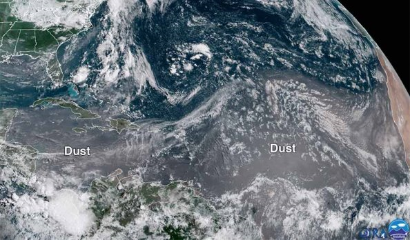
Figure 3 below shows the large plume of African dust across the Main Development Region (MDR). June and July are typically the most active months for transport of African dust across the Atlantic. However, an unusually concentrated plume of African dust has spread across the tropical Atlantic and into the Caribbean over the past two to three weeks. The dust blocked enough sunlight to cool SSTs by more than 0.5°C, relative to average, over most of the tropical Atlantic and Caribbean during this period (though stronger-than-average trade winds contributed, as well).
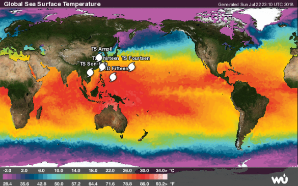
Figure 4 below shows a very different story in the Western Pacific Ocean - a very active western Pacific with 5 names tropical systems between 22nd and 23rd July. Why such high activity in this region at the present time? Generally, the Madden Julian Oscillation (MJO), a pattern of increased thunderstorm activity near the Equator that moves around the globe in 30 - 60 days, is currently located in the Western Pacific Ocean, favoring typhoon development there. Whenever the MJO is located in the Western Pacific hurricane activity in the Atlantic is at a minimum. The MJO is moving eastwards slowly and should favor Atlantic hurricane activity by mid-August, but the MJO’s strength is unknown at this point, and if weak, will have no effect on hurricane activity.
Finally, the last factor influencing a rather quite July hurricane season is the presence of wind shear. Wind shear is the increase of windspeed with height. For tropical systems to grow and mature into strong hurricanes, no wind shear should be present. Wind shear has been near-average to above-average over most of the tropical Atlantic over the past week or two and is predicted to remain that way during the coming week, at least. It does not appear that the slow progression towards El Niño has brought El Niño-like very high wind shear to the tropical Atlantic yet, however, signs are pointing to that happening by September as El Niño starts strengthening.
The bottom line is that hurricane activity should pick up by mid-August into September. Time will tell how the developing El Niño’s wind shear effects will affect hurricane activity in September and October.
Weekly Outlook:
Here is what to expect regarding precipitation and temperature in the coming week.
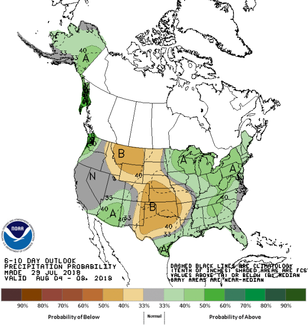
Figures 5 and 6 below show the expected 6-10-day temperature and precipitation outlooks. The colored shading on the map indicates the degree of confidence the forecaster has in the category indicated, where "B" and blue colors indicate "below-normal" and "A" and orange-red colors indicate "above normal". The darker the shading, the greater is the level of confidence. The numbers labeling the contours separating different shades gives the probability that the indicated category (A, B, or N) will occur.
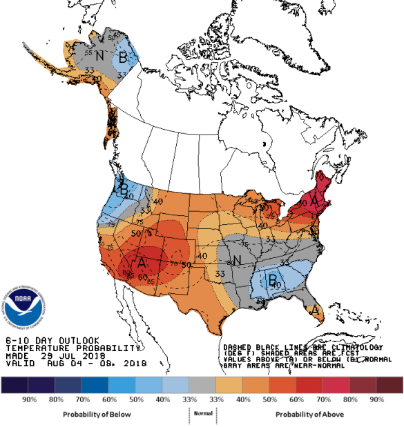
Generally, the probability of below average temperatures (as seen in Figure 5) is low over much of the Pacific Northwest, over the Deep South, centered on central Alabama, covering most of Mississippi, Alabama, Georgia and South Carolina and also over the extreme northeastern areas of Alaska. In general the probability is moderate to high that the Midwest and the entire New England region will experience above average temperatures. Southern Alaska, southern Florida and the Four Corners region and most of the western Plains States should expect moderate probabilities of above average temperatures. Much of the Mississippi River Valley region, the eastern areas of the Central and Southern Plain States, much central and southern areas of Virginia and North Carolina will experience normal temperatures for this time of the year.
The precipitation outlook for the next 6-10 days (Figure 6) shows the probabilities are low to moderate for below average rainfall over much of the Plains States from Texas in the southern stretching northwest into the Northern Tier states, centered on Montana. Moderate probabilities for above average rainfall exists over much of the rest of the eastern third of the United States from Florida to New England in the east westwards to Minnesota in the north and Louisiana in the south. Much of Alaska has a low to moderate chance of above average rainfall. Most of California, Nevada, and the eastern areas of the Pacific Northwest should experience average rainfall for this time of the year.
Weekly hazards output by the NWS’s Climate prediction center for the next 3-7 days is shown in Figure 7 below.
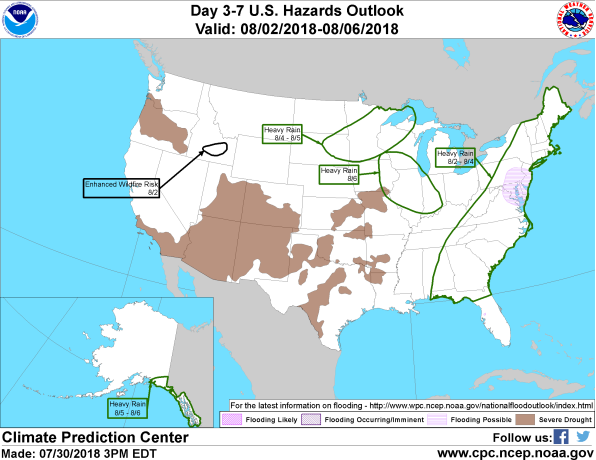
Figure 7 shows that most of the expected weather hazards over the United States in the next 3 to 7 days. Heavy rain should be expected over the enter East Coast from northern Florida into New England between the 2nd and 4th August with flooding possible over far northern Virginia, Delaware much to New Jersey and southeastern Pennsylvania. Heavy rains are expected between the 4th and 5th August over northeastern South Dakota, most of Minnesota and northwestern Wisconsin. Heavy rain is also likely on the 6th August over much of southern Wisconsin, most of Illinois and western Indiana. Heavy rain should also be expected between the 5th and 6th August over far southeastern Alaska. An enhanced wildfire risk exists on the 2nd August over a small area of southern Idaho.
Want to know precisely who NOT to contact during a disaster?
Find out with a free trial