Santa's coming to town and he's bringing the polar vortex!
Meteorologist Dr. Kevin Levey takes a look at polar vortex coming in January 2019
Tuesday, 25 December 2018 11:45:00 -06:00
Season’s greetings! For the past week, many atmospheric scientists and meteorologists have been excited about a potential meteorological event that certainly does have implications for the weather over the United States. When meteorologists get excited then you know something interesting is about to happen. For some of you, the mention of “polar vortex” may have sent shivers down your spine. An atmospheric researcher with the Atmospheric and Environmental Research group who monitors the conditions of the polar vortex is concerned what some models have been predicting at the end of December or early January. Furthermore, he noted that “confidence is growing in a significant Polar Vortex disruption in the coming weeks. This could be the single most important determinant of the weather this winter across the Northern Hemisphere,”
OK, so let’s just refresh our memories of exactly what the polar vortex is.
The Polar Vortex
Essentially, it is the boundary between very cold polar air situated over the polar regions and warmer air to the south (in the northern Hemisphere). It can also be seen as the nondairy between lower pressure in the upper levels of the atmosphere over the polar regions and higher pressure to the south (in the northern hemisphere). Figure 1 below shows a typical pattern of the Arctic Polar Vortex.
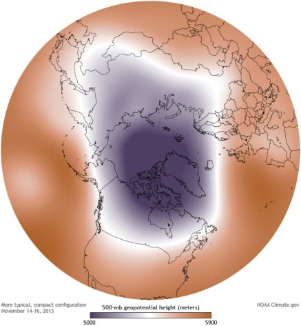
This whole area of low pressure rotates in a counter-clockwise manner at the North Pole. The boundary between the lower pressure (and colder air) over the North Pole and the higher pressure (warmer air) is where we find the Jetstream and is where the sharpest differences between the lower and higher pressure occurs (and also between the warmer and colder air. The colder the air is over the North Pole and the warmer the air is to the south, then the stronger the Jetstream as it is directly proportional to the gradient (change over distance) of air pressure and temperature. Under normal conditions in winter, the Jetstream becomes stronger as the polar regions get colder and the difference in pressure and temperature across the boundary becomes greater. This more typical pattern of the polar vortex as shown in Figure 1 creates a stronger, more zonal Jetstream pattern, meaning the flow and tracks of the accompanying winter storms is more in an east-west orientation moving from the west towards the east and the west coast receives abundant rain and very cold outbreaks over the United States are generally rare as the very cold air remains north of the zonal Jetstream in Canada.
However, during some winters, the air over the Arctic is warmer than normal and/or the air to the south of the polar vortex (in the northern Hemisphere) is cooler than average. Air temperatures to the south of the polar vortex in the Northern hemisphere are greatly influence by phenomena like EL Niño/La Niña and the Pacific Decadal Oscillation (previously covered in this blog). During strong EL Niño years, the difference in pressure and air temperature across the boundary of the polar vortex is much greater than during normal winters and much weaker during La Niña years. Figure 2 below shows the typical “wavy” pattern of the polar vortex when pressure and temperature gradients are weak across the boundary and the Jetstream is weaker than normal.
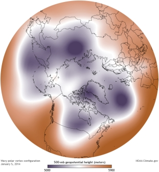
During this type of pattern, the Jetstream becomes less zonal and more meridional, meaning, it meanders north and south instead of being in a more east-west alignment. Figure 3 below summarizes the differences between a strongly zonal patter and a strongly meridional pattern.
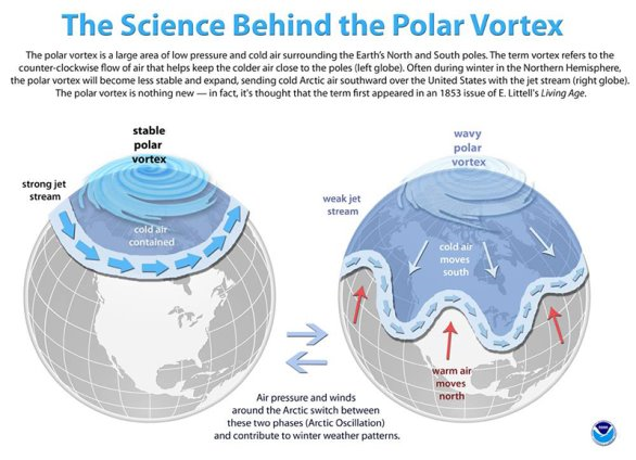
During a weak Jetstream/wavy polar vortex pattern (Figure 3, right) very cold air from the polar regions (called low pressure troughs) is able to penetrate far south into the United states in some places, while very warm air is able to surge far northwards (called high pressure ridges) into Canada in other places. Often the location of the troughs and ridges and hence, the warmer/colder than normal remain in places for days to weeks on end in a pattern called a “blocking” pattern. December 2017 was a classic example of this “stuck” or “blocking” pattern over the United States where we had a strong high pressure ridge (and warmer than normal temperatures and near zero rainfall) over the western half of the country, and a low pressure trough (colder than normal temperatures and above average precipitation) over the eastern half of the country. Figure 4 below shows this very well indeed.
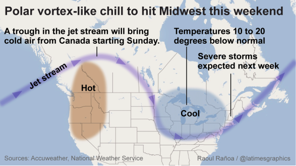
So, you ask, what is this “big event” I mentioned in opening paragraph. As explained above, when the polar vortex, located around 60,000 feet high in the atmosphere, is stable, winter conditions over the United States and Europe tend to be rather ordinary. Winter is still winter, with the normal mix of storms, cold snaps and thaws.
But when the polar vortex is disrupted, an ordinary winter can suddenly turn severe and memorable for an extended duration - it can affect the entire winter. The polar vortex essentially becomes more “wavy” as seen in the a-typical pattern in Figure 3. And depending on how the pattern manifests itself (and tends to become stagnant or “stuck”), certain areas may have a surge of cold air from the polar regions (most likely the eastern third of the USA) which the western parts may have a surge of warmer air form the tropics. Think back to February of this year to understand the implications. Up to that point, the vortex had held in its stable state, and the winter was a mild, unremarkable one. But then, abruptly, the vortex split. The fracture set off a chain reaction, which first unleashed a punishing blast of cold in Europe and Asia. The media dubbed the cold snap the “beast from the east” as frigid Siberian air flooded the continent.
A strong, persistent ridge of high pressure set up of the west coast during February with significant rainfall deficits. Then, the piercing cold hit the Lower 48 states in March. It triggered four consecutive nor’easters along the East Coast, where the polar air collided with the relatively mild Atlantic waters. Its effects lasted weeks. The impacts were still been felt into the end of April across the entire USA. Similar polar vortex disruptions defined the character of several other extreme winters, including 2009-2010, the snowiest on record in parts of the Mid-Atlantic, and 2013-2014, which was abnormally cold, especially in the Great Lakes.
But before you start running to the stores to buy a warmer coat, the polar vortex behavior can be fickle and is difficult to predict. The American modeling system favors a disruption this month, while the European modeling system delays it until early January. Polar vortex disruption is associated with a phenomenon known as a sudden stratospheric warming (SSW) event. The stratosphere is the layer of air in which the polar vortex resides, above the troposphere, where most weather occurs (there is also a tropospheric polar vortex, which is at times linked to the vortex in the stratosphere). During such a stratospheric warming event, the prevailing winds decrease or even change direction, the layer warms, and the vortex is displaced and sometimes splits apart.
Generally, the effects on the surface weather patterns is felt 7-14 days after this polar vortex disruption, so the eastern third of the country may only see the very cold air in mid to late January *if* this major forecasted disruption of the polar vortex occurs. Forecasting stratospheric warming events is still a young science, and model predictions aren’t always that reliable. In this case, confidence is boosted somewhat by the fact that every simulation in the American modeling system projects stratospheric warming within the next 16 days. Not all other models on board yet so still reason to be cautious. As of today, rapid warming of the stratosphere above Finland has been observed, so it is safe to say the event has started, but time will tell how this all unfolds.
Weekly Outlook:
Here is what to expect regarding precipitation and temperature in the coming week.
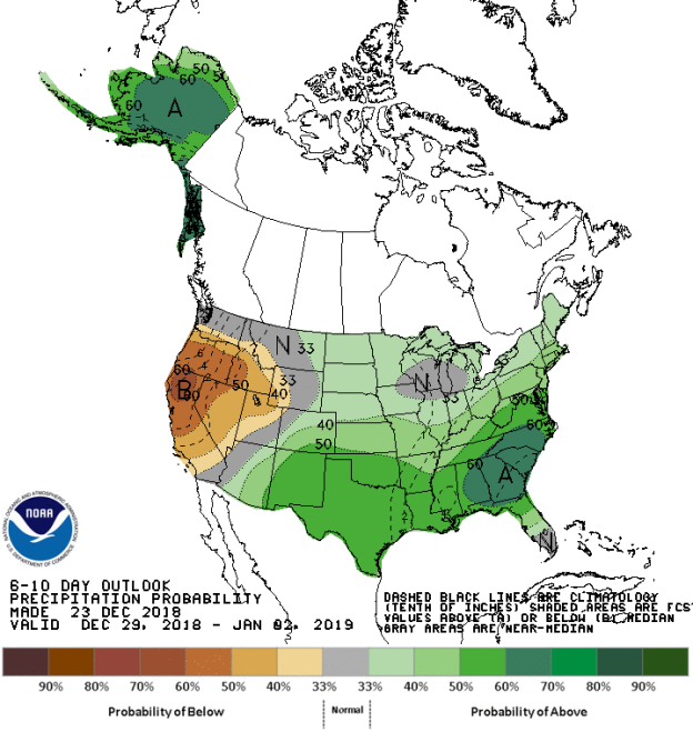
Figures 5 and 6 below show the expected 6-10-day temperature and precipitation outlooks. The colored shading on the map indicates the degree of confidence the forecaster has in the category indicated, where "B" and blue colors indicate "below-normal" and "A" and orange-red colors indicate "above normal". The darker the shading, the greater is the level of confidence. The numbers labeling the contours separating different shades gives the probability that the indicated category (A, B, or N) will occur.
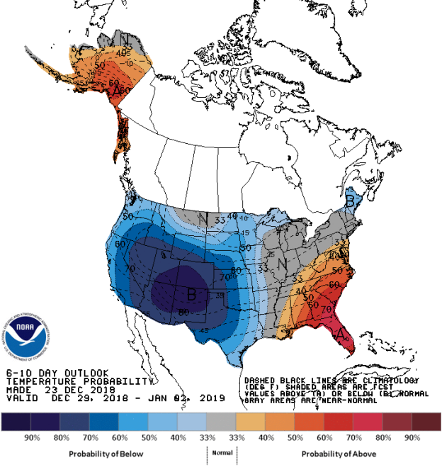
In stark contrast to last week, the probability of above average temperatures (as seen in Figure 5) is generally low over Alaska and moderate over the southeastern areas of the USA, including Florida. In general, the probability is moderate to high that the entire western half of the United States will experience below average temperatures, centered over the Four corners. Most of the Mississippi Valley north into the Midwest and the Ohio Valley will experience normal temperature for this time of the year.
The precipitation outlook for the period 6-10 days out (Figure 6) shows moderate probability of below average precipitation over Oregon, California, Nevada and southern Idaho and northern Utah. A low to moderate chance for above average rainfall exists over Alaska and for much of the rest of the country, especially over Georgia and the Carolinas. Most of Washington, Montana, southern Wisconsin, central Wyoming should expect to receive average rainfall.
Weekly hazards output by the NWS’s Climate prediction center for the next 3-7 days is shown in Figure 7 below.
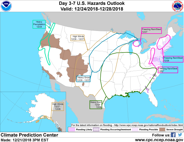
Figure 7 shows expected weather hazards for the next 3 to 7 days. Heavy precipitation is expected over Sierras, far Northern California and over the Cascades from Oregon into Washington on the 24th December. Heavy rain is expected over a large area of the southeastern USA stretching northwards into Iowa, Illinois and parts of the Ohio Valley between the 26th and 28th December. Heavy snow is expected over a large swatch stretching from northwestern Oklahoma stretching northeastwards into the U.P. of Michigan between the 26th and 27th December. Freezing rain/sleet is possible over a few different areas: northern Michigan on the 27th December, large area of New England (eastern New York, Vermont and New Hampshire) on the 28th December and over eastern West Virginia and parts of western Pennsylvania on the 27th December. High winds are possible over southern Alaska between the 27th and 28th December and also over large area of the central parts of the US, from New Mexico and western Texas in the south stretching northeastwards into Minnesota and the U.P. of Michigan between the 26th and 27th December.
