ContactRelief Wildfire Recommendations for Contact Centers
ContactRelief recommends suspending contact with consumers affected by the Bear fire near San Jose, California and resuming contact selected areas affected by the California wildfires.
Wednesday, 18 October 2017 14:00:00 -05:00
For as little as $300 per month, your company can avoid disasters by shaping the customer experience.
Sign up Now
Contact Recommendations for Contact Centers
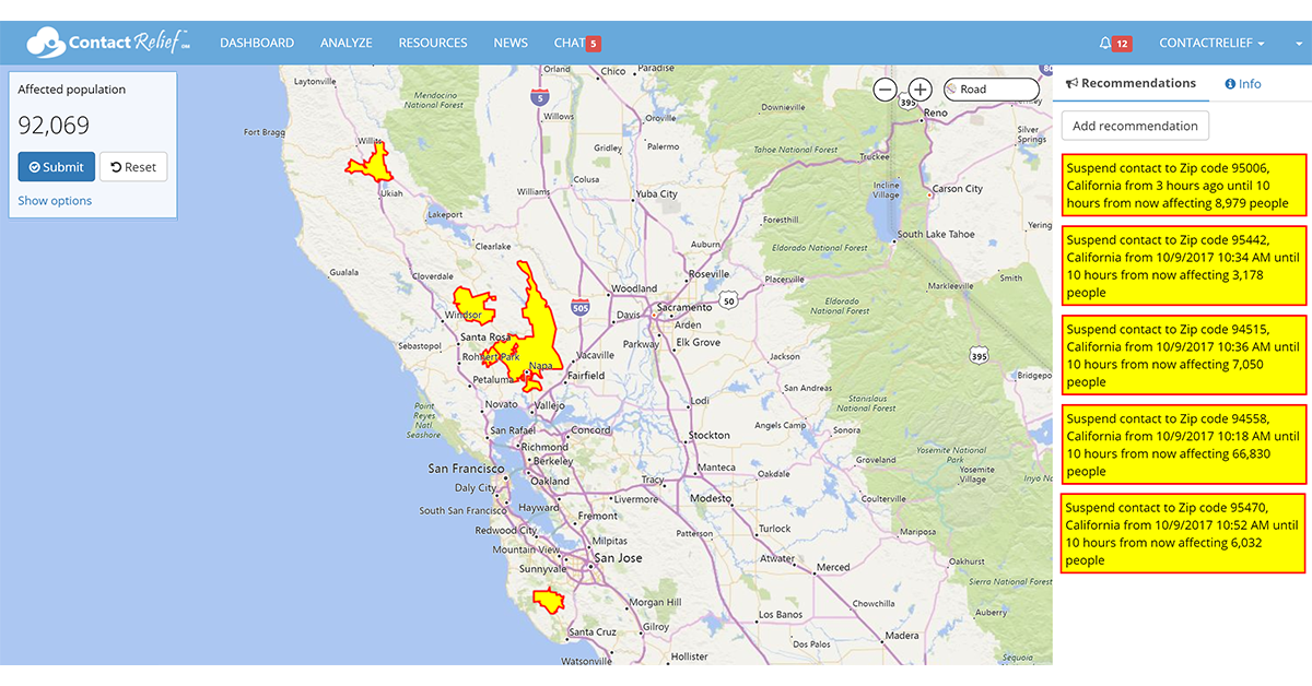
ContactRelief is making public recommendations made to its subscribers, Tuesday, October 18th. To obtain the list of suspended zip codes, become a ContactRelief subscriber.
ContactRelief recommends suspending contact with consumers in the area affected by the Bear Fire evacuations near near San Jose, California.
ContactRelief's prior recommendation to suspend contact with consumers affected by the Atlas, Nuns, Redwood Valley, and Tubbs fires remains in force. All other wildfire suspensions in California are lifted.
California Wildfire Update
Over the past week, California firefighters, joined by wildfire specialists from across the country, have battled a dizzying array of wildfires from the wine country of northern California to Los Angeles. Hampered by extremely dry conditions and high winds, firefighters fought a mostly losing battle for much of last week but have finally started to get the upper hand in many areas. Although there are no current red flag warnings for California, as we noted in this week's Wild Wild Wildfire Weather installment of our Weather Insights blog with ContactRelief meteorologist Dr. Kevin Levey, October weather conditions over California make it especially conducive to wildfires.
In fact, a new wildfire, known as the Bear Fire, has ignited today in Santa Cruz County. The fire has already consumed 271 acres, closed roads in the area, and forced officials to issued new evacuation orders. California's Department of Foresty and Fire Protection said today that "The fire is burning to the north, west, and east in steep inaccessible terrain covered by drought-stressed fuels in heavy timber. Today’s low humidity, combined with little to no nighttime humidity recovery, is hampering control efforts."
ContactRelief has monitored the fire threat from the beginning, issuing recommendations at noon and 7 PM on October 9th and additional recommendations on October 12th.
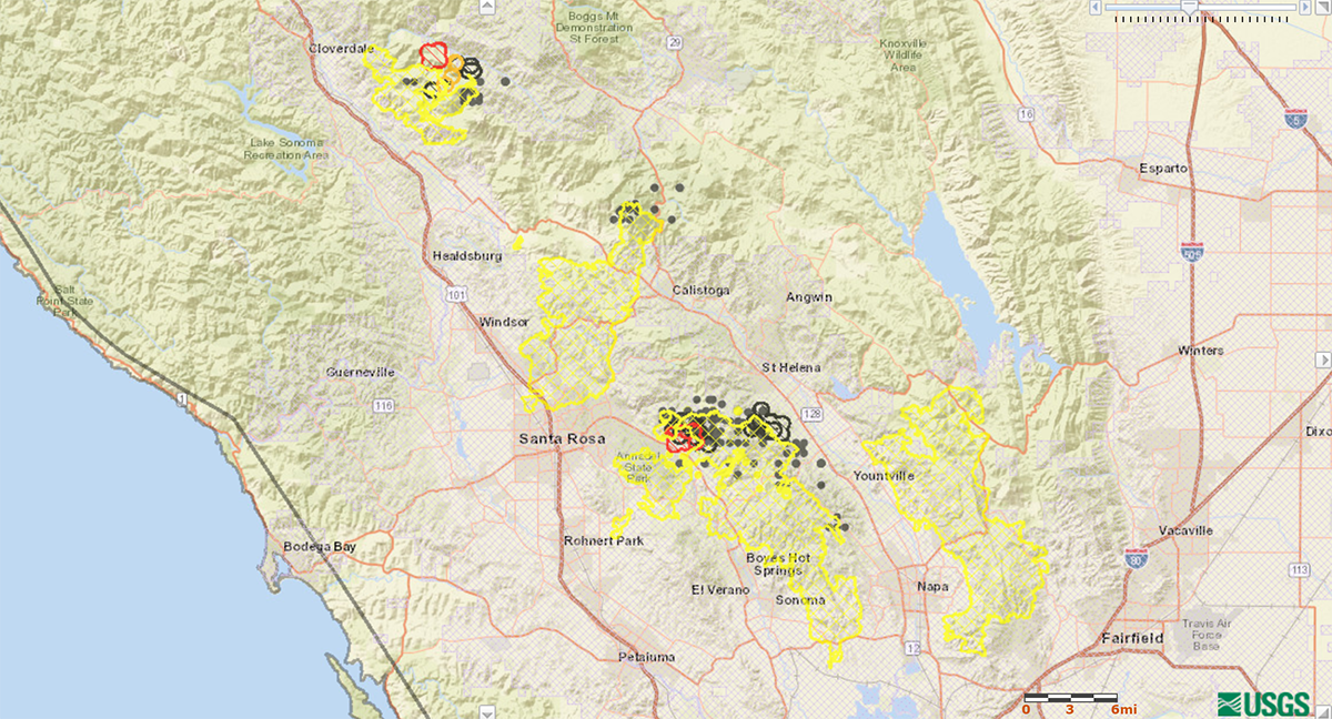
In making these recommendations, we considered a number of factors including the threat to populated areas, the existence of evacuation notices, and the actual or predicted cost in lives and property damage. Most wildfires occur in remote areas. To assess the threat to population centers we use the fire perimeter, shown in yellow in Figure 1 below, overlaid with population boundaries (shown as red cross-hatching in Figure 1 below) determined from nighttime satellite photos of human-generated visible and near-infrared lighting leaking into outer space. Figure 1 also shows the areas of active fire within the last 24 hours (red), 48 hours (orange), or older than 48 hours (grey). We recommend contact suspensions for wildfires at the zip code level where possible to properly cover the affected evacuation areas without suspending contact to large populations outside the affected region.
Wildfires are named according to their point of origination, but closely related wildfires are often grouped for easier reporting in what is known to the fire community as a "complex". The status of the active California wildfires by complex is provided below.
Central LNU Complex Fires – Napa/Sonoma counties, California
Started: October 8th
Fatalities: 22
Structures Destroyed: 5,017
Evacuations: Yes
Nuns Fire
- Acres burned: 20,025
- Containment: 80%
Pocket Fire
- Acres burned: 12,430
- Containment: 63%
Tubbs Fire
- Acres burned: 36,432
- Containment: 91%
Southern LNU Complex Fires – Napa/Solano counties, California
Started: October 8th
Fatalities: 22
Structures Destroyed/Damaged: 421/66
Evacuations: Yes
Atlas Fire
- Acres burned: 51,064
- Containment: 83%
Mendocino-Lake Complex Fires – Redwood Valley, Mendocina County
Started: October 9th
Fatalities: 8
Structures Destroyed/Damaged: 699/52
Evacuations: Cancelled
Redwood Valley Fire
- Acres burned: 35,800
- Containment: 75%
- Acres burned: 2,207
- Containment: 92%
Wind Complex Fires – Butte, Nevada, Yuba counties, California
Started: October 8th
Fatalities: 4
Structures Destroyed/Damaged: 398/16
Evacuations: Cancelled
Cascade Fire
- Acres burned: 9,989
- Containment: 98%
LaPorte Fire
- Acres burned: 6,151
- Containment: 98%
Lobo Fire
- Acres burned: 821
- Containment: 99%
McCourtney Fire
- Acres burned: 76
- Containment: 100%
Other Fires
Canyon 2 Fire – Orange/Riverside counties, California
- Started: October 9th
- Acres burned: 9,217
- Containment: 100%
- Fatalities/Injuries: 0/0
- Damage: 80 structures
- Evacuations: Cancelled
Cherokee Fire – Butte county, California
- Started: October 8th
- Acres burned: 8,417
- Containment: 100%
- Fatalities/Injuries: 0/0
- Damage to strctures: None
- Evacuations: Cancelled
Why You Must Also Prepare for Man-Made Disasters - The Las Vegas Mass Shooting
Contact centers need to be prepared to act quickly and decisively not only for forecasted events like hurricanes, but also for man-made disasters that cannot be predicted. On Sunday night in Las Vegas, over 50 people were killed and over 500 injured in a senseless mass shooting at a local music festival.
ContactRelief issued a recommendation to suspend contact to accounts with zip codes surrounding the Las Vegas Strip on October 2nd at 12:30 AM PDT, a little more than 2 hours after the incident began, and expanded this contact suspension recommendation at 4:30 AM PDT to include all of the county surrounding Las Vegas (Clark County, Nevada) as more details became known.
If you are like most companies, you can't afford the staff to perform the around the clock monitoring required to act promptly, the management of multiple concurrent disasters, and information gathering it takes to know when and where to suspend and resume contact for all types of possible events. But why bother when ContactRelief has this and more for less than $300 per month.
Why You Must Act Now
Our offer of free access to our service will expire soon. We provide the only service specially designed for contact centers and focused on all aspects of the customer experience during natural and man-made disasters. We can not only tell you when and where to suspend contact, but when and why you should resume contact, and how you can improve your brand image by the actions you take during these periods. Because before starting ContactRelief we owned and operated large contact centers, we understand your business perspective, and our recommendations are designed to help you deliver a great customer experience while still enabling you to achieve your other objectives.
Don't Delay
The next disaster is on its way. Become a ContactRelief subscriber and keep your company protected from disaster. Our full recommendations consist of the areas to be suspended and the list of zip codes covering these areas. For as little as $300 per month your company can quickly implement a solution that protects your company and its customers. As we say at ContactRelief, "It's just smart business."
Contact sales@contactrelief.com for more information.
Protect your brand AND revenue when disaster strikes.
Try ContactRelief FREE for 30 days. Discover how we can help you reach up to 5x more customers in a disaster zone – while protecting your brand image.
Start free trial