Beryl Weakens as Tropical Depression Forms Off Eastern Seaboard
Beryl weakens back to Tropical Storm intensity
Saturday, 07 July 2018 11:30:00 -05:00
Tropical Storm Beryl
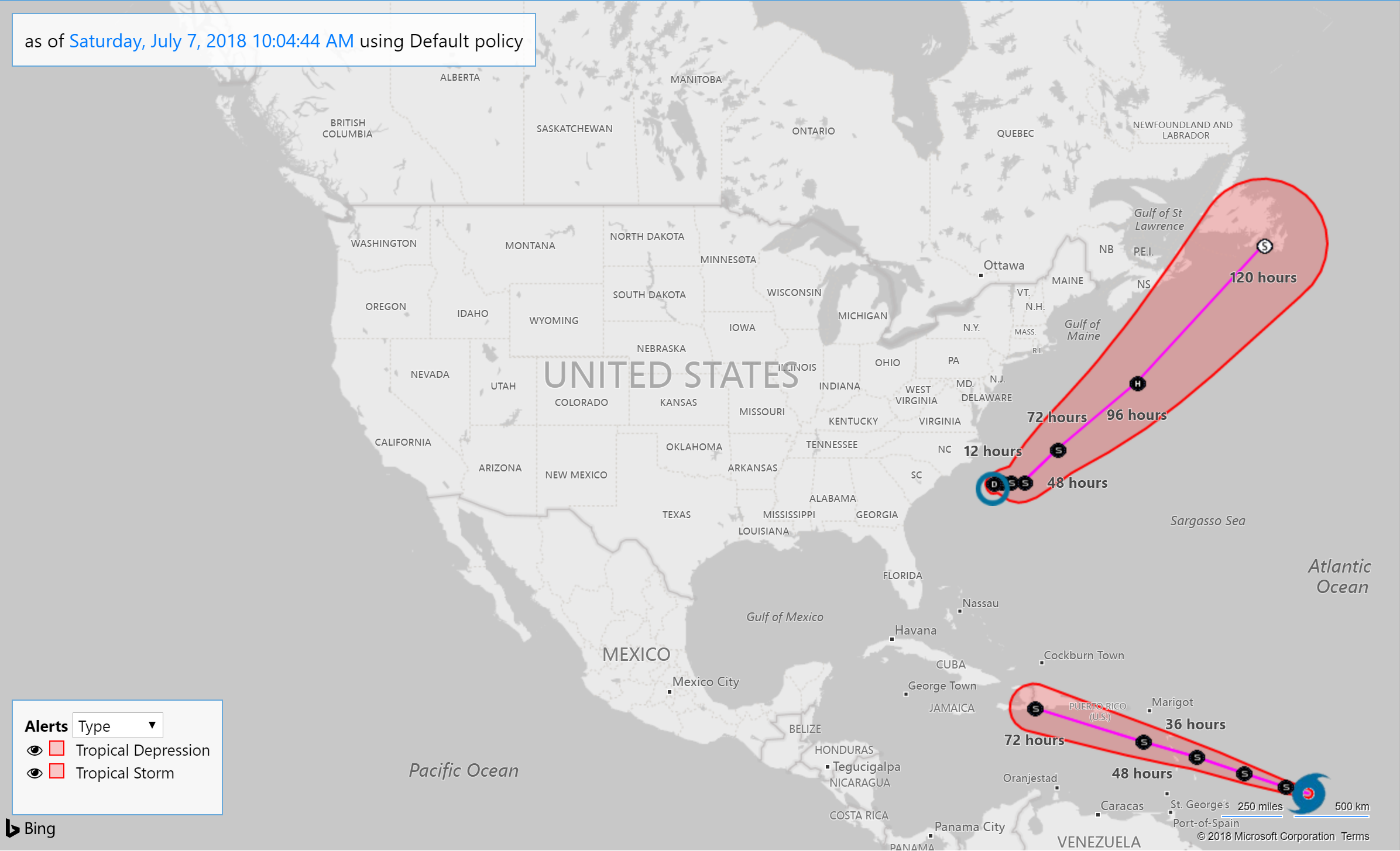
As expected Tropical Storm Beryl has weakened back to Tropical Storm intensity as upper level wind shear disrupts the storm ability to organize. Located at near latitude 12.1 North, longitude 51.1 West, Beryl is moving toward the west-northwest near 14 mph. The National Hurricane Center (NHC) said in its 11 AM AST advisory that the center of Beryl will approach the Lesser Antilles over the weekend, cross the island chain late Sunday or Monday, move south of the Virgin Islands and Puerto Rico on Monday and Monday night, and then degenerate into an open trough by the time it reaches the central Caribbean Sea and Hispaniola on Tuesday.
A Tropical Storm warning is in effect for Dominica, and Tropical Storm Watches are in effect for Barbados, St. Lucia, Martinique, Guadeloupe, St. Martin, St. Barthelemy, Saba, and St. Eustatius. Beryl is a small tropical storm. Tropical-storm-force winds extend outward only up to 35 miles from the center. On it present forecast track, tropical force winds should pass just south of the Puerto Rico and well south of the U.S. Virgin Islands.
Tropical Depression Three
As forecasters at the NHC expected, a distrubance off the eastern seaboard has intensified becoming the third Altantic Tropical Depression of 2018. Tropical Depression Three is located near latitude 33.1 North, longitude 74.8 West, moving slowly toward the north near 2 mph with little motion anticipated over the next 2 days.
Maximum sustained winds remain near 30 mph with higher gusts. Some strengthening is forecast during the next several days, and the depression could become a tropical storm later tonight or on Sunday. An Air Force reconnaissance plane is currently approaching the depression with updated advisories expected in the next few hours.
Forecasters at the NHC say the depression is expected to begin moving toward the northeast by Tuesday keeping it away from the US coast line. However, swells generated by the depression are expected to increase and affect portions of the coasts of North Carolina and the mid-Atlantic states this weekend. These swells could cause life-threatening surf and rip current conditions.
Recommendations for Contact Centers
Tropical Storm Beryl and Tropical Depression Three appear to pose little threat to U.S. interests at this time. However, should Beryl's forecast track deviate northward, Puerto Rico could experience tropical force winds, and in any case Tropical Storm Warnings or Watches may be issued by the National Hurricane Center. Tropical Depression Three is expected to generated sea swells but have no other major impacts.
Contact centers should monitor the forecast track, wind field size, and arrival time of tropical force winds in the ContactRelief Command Center and take action if there is any deviation of either storm's forecasted track. Contact to Puerto Rico should be amplified as a defense against potential changes in the forecast track that may make communication with Puerto Rican residents unadvisable until the storm passes. No other action is recommended at this time.
The ContactRelief Disaster Decision Team will continue to monitor the storm's development and issue additional advisories as warranted.
For as little as $400 per month, your company can avoid disasters by shaping the customer experience.
Schedule Your Product Demo Now!
Don't Delay
The next disaster is on its way. Become a ContactRelief subscriber and keep your company protected from disaster. Our full recommendations consist of the areas to be suspended and the list of zip codes covering these areas. For as little as $400 per, month your company can quickly implement a solution that protects your company and its customers. As we say at ContactRelief, "It's just smart business."
Contact sales@contactrelief.com for more information.
