Florence, Olivia, Mangkhut Threaten North Carolina, Hawaii, and Guam
Evacuations start in North Carolina
Monday, 10 September 2018 11:00:00 -05:00
ContactRelief Recommendations for Contact Centers
ContactRelief is making public recommendations first made to subscribers on Monday, September 10th, 2018. ContactRelief recommends suspending contact with (or continuing suspension of contact with):
- Guam and the Northern Mariana Islands due to Typhoon Mangkhut which passed over the islands in the early morning hours today,
- The Hawaiian Islands due to the impending approach of Hurricane Olivia, and
- Parts of South Carolina, North Carolina, and Virginia due to the impending approach of Hurricane Florence
To obtain the list of affected ZIP Codes, become a ContactRelief subscriber today.
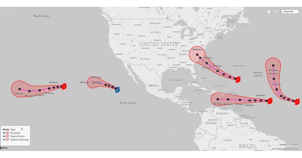
Hurricane Florence
Hurricane Florence continues its rapid intensification as it moves on a forecast tracked toward the Mid-Atlantic coastline. Florence, now a Category 4 storm, is expected to make landfall in North Carolina late Thursday or early Friday. Evacuations have begun in the outer islands of North Carolina.
At 1100 AM AST (1500 UTC), the eye of Hurricane Florence was located near latitude 25.0 North, longitude 60.0 West moving toward the west near 13 mph (20 km/h). On the forecast track, the center of Florence will move over the southwestern Atlantic Ocean between Bermuda and the Bahamas Tuesday and Wednesday and approach the coast of South Carolina or North Carolina on Thursday. The National Hurricane Center says that Florence may dump 20-30 inches of rain.
Hurricane Olivia
Category 1 Hurricane Olivia continues on a path to hit Hawaii on Wednesday as a Tropical Storm. Like Hurricane Lane that affected Hawaii little more than three weeks ago, the damage from Hurricane Olivia is expected to be due to rain and flooding, not wind. Residents will likely be more active in their preperations given their recent experience with Lane.
Typhoon Mangkhut
Typhoon Mangkhut passed over the island of Guam in the early morning hours today. Typhoon or Tropical force winds are expected to continue to batter the island today. Winds of up to 105 mph with gust to 120 mph have been reported. Power outages were reported earlier in some areas. It is too soon to understand the extent of the damage as not typhoon and tropical force winds are not expected to die down until later today.
ContactRelief is monitoring the storms
The ContactRelief Disaster Decision Team will continue to monitor the development of these storms and issue additional advisories as warranted.
With ContactRelief's Disaster Decision Engine, your company can avoid disasters by shaping the customer experience.
Schedule Your Product Demo Now!
Don't Delay
The next disaster is on its way. Become a ContactRelief subscriber and keep your company protected from disaster. Our full recommendations consist of the areas to be suspended and the list of zip codes covering these areas. With minimal effort, your company can quickly implement a solution that protects your company and its customers. As we say at ContactRelief, "It's just smart business."
Contact sales@contactrelief.com for more information.
What can ContactRelief do for you?
Are you ready to see how ContactRelief can shape your disaster operations strategy? Schedule your customized demo to see firsthand how ContactRelief can reduce your workload, protect your brand and improve your contact efficiency.