New Tropical Storm Forms as Beryl Heads Towards Puerto Rico
Tropical Storm Chris expected to reach Hurricane strength
Sunday, 08 July 2018 08:45:00 -05:00
Tropical Storm Beryl
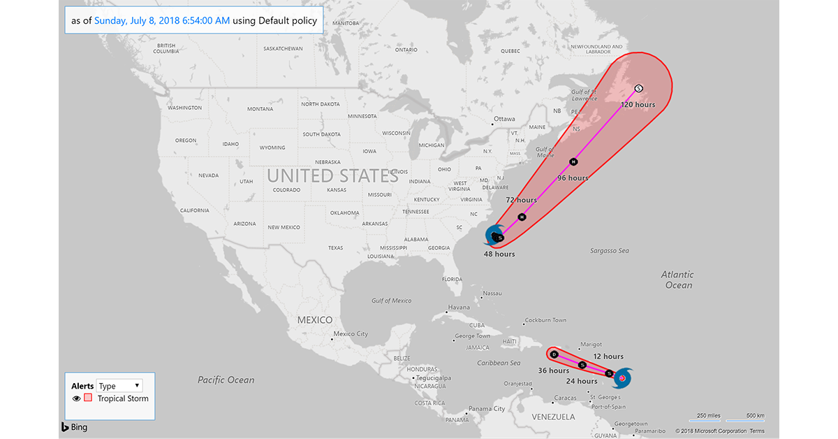
Tropical Storm Beryl continues on its forecasted track but forecasters at the National Hurricane Center say the storm has become more disorganized. On its current track, Beryl is still projected to pass just south of Puerto Rico. However, the 3 day forecast track cone of probability encompasses the island meaning that the center has a possbility of passing directly over the island.
As of 8 AM AST, Tropical Storm Beryl was located near latitude 14.0 North, longitude 56.8 West moving toward the west-northwest near 20 mph with an increase in forward speed expected during the next couple of days. Berly has maximum sustained winds near 45 mph with higher gusts. Gradual weakening is anticipated during the next 48 hours, and Beryl is forecast to degenerate into a trough of low pressure as it moves across the Lesser Antilles and into the eastern Caribbean Sea by Monday.
WIND: Tropical storm conditions are expected in Dominica and Guadeloupe tonight. Tropical storm conditions are possible in the watch areas of the Lesser Antilles by later today or Monday. Strong gusty winds are also possible in the Virgin Islands and Puerto Rico on Monday.
RAINFALL: Beryl is expected to produce total rain accumulations of 1 to 3 inches through Monday across the southern Leeward and northern Windward Islands. Across Puerto Rico, rainfall amounts of 1 to 4 inches are expected. Across the remainder of the Leeward and Windward Islands and the Virgin Islands, rainfall amounts of 1 to 2 inches are expected, with locally higher amounts possible.
Tropical Storm Chris
Tropical Storm Chris continues to meander of the coast of the Carolinas. The storm is expected to begin to accelerate toward the northest on Tuesday keeping it away from the U.S. coastline.
Maximum sustained winds have increased to near 40 mph with higher gusts and tropical-storm-force winds extending outward up to 60 miles from the center. Forecasters at the National Hurricane Center said "Additional strengthening is forecast, and Chris is expected to become a hurricane by mid-week."
SURF: Swells generated by Chris are expected to increase and affect portions of the coasts of North Carolina and the mid-Atlantic states into early next week. These swells could cause life-threatening surf and rip current conditions.
WIND: Winds to gale force not directly associated with Chris are expected along the North Carolina coast and over Pamlico and Albemarle Sounds during the next day or so.
Recommendations for Contact Centers
Tropical Storm Beryl is now expected to weaken to Tropical Depression strength before reaching Puerto Rico and the Virgin Islands. The major impact to the area will likely be rain with localized flooding possible. Tropical Storm Chris is expected to reach Hurricane strength but remain over open water as it tracks northeast up the U.S. coast. However, as shown below, the estimated arrival time of wind prediction from the National Hurricane Center indicates a possibility of Tropical Force Winds affecting the U.S. coast from South Carolina to Maine. Tropical Storm Warnings or Watches for the affected areas may be issued by the National Hurricane Center over the coming days.
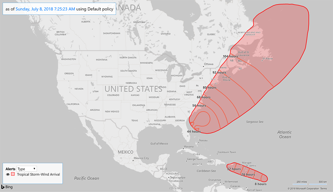
Contact centers should monitor the forecast track, wind field size, and arrival time of tropical force winds in the ContactRelief Command Center and take action if there is any deviation of either storm's forecasted track. Hard hit Puerto Rico should be monitored for flooding or other adverse conditions as Tropical Storm Beryl passes through the area. Contact with areas within Tropical Storm Chris's estimated arrival time of winds prediction should be amplified as a defense against potential Tropical Storm Warnings or Watches being raised in the coming days.
The ContactRelief Disaster Decision Team will continue to monitor the storm's development and issue additional advisories as warranted.
For as little as $400 per month, your company can avoid disasters by shaping the customer experience.
Schedule Your Product Demo Now!
Don't Delay
The next disaster is on its way. Become a ContactRelief subscriber and keep your company protected from disaster. Our full recommendations consist of the areas to be suspended and the list of zip codes covering these areas. For as little as $400 per, month your company can quickly implement a solution that protects your company and its customers. As we say at ContactRelief, "It's just smart business."
Contact sales@contactrelief.com for more information.
Are you prepared for the next disaster?
Disasters can strike at a moment’s notice. That’s why, at ContactRelief, we provide round the clock disaster monitoring to keep your operations ahead of disasters. With timely, comprehensive recommendations that are accurate to the ZIP code, ContactRelief ensures you focus less on the disaster, and more on your operations.
Contact sales@contactrelief.com for more information.