5 Hurricane Facts Risk and Contact Center Professionals Should Know
ContactRelief Meteorologist Dr. Kevin Levey explains 5 important hurricane facts risk managers and call center professionals need to know.
Monday, 07 August 2017 11:00:00 -05:00
Hurricanes are complex forces of nature and are often not well understood, however, their potential and devastating effects are well known. There are many questions that people generally ask regarding hurricanes. This article will endeavor to answer some of the most frequently asked questions as we move deeper into the Atlantic hurricane season.
1. What is a hurricane, typhoon, or tropical cyclone?
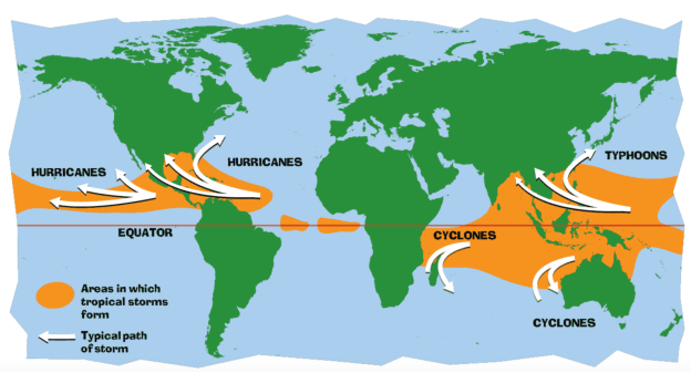
Essentially, they are all the same thing, i.e. a regionally specific name for a “tropical cyclone". The generic term “tropical cyclone" essentially describes a synoptic (large-scale) low-pressure system over tropical or sub-tropical waters associated with a definite cyclonic (counter-clockwise in the Northern Hemisphere and clockwise in the southern Hemisphere) surface wind circulation and organized convection (thunderstorm activity). Figure 1 below shows where tropical cyclones occur in the world and more specifically:
- Hurricane - The North Atlantic Ocean, the Northeast Pacific Ocean east of the dateline, or the South Pacific Ocean east of 160° E
- Typhoon - The Northwest Pacific Ocean west of the dateline
- Severe Tropical Cyclone or Category 3 Cyclone and above - The Southwest Pacific Ocean west of 160° E or Southeast Indian Ocean east of 90° E
- Very Severe Cyclonic Storm - The North Indian Ocean
- Tropical Cyclone - The Southwest Indian Ocean
2. What is a tropical disturbance, a tropical depression, or a tropical storm?
Every hurricane undergoes a typical life cycle and each term below is a progressive level of organization and are generally determined by the speed of the surface winds. Figure 2 below shows the different stages.
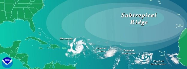
- Tropical Disturbance - A discrete tropical weather system of apparently organized convection – generally 100 to 300 miles in diameter which originates in the tropics or sub-tropics and maintains its identity for 24 hours or more. Tropical Disturbances are also known as easterly waves as they move in the tropical easterly wind flow from east to west.
- Tropical Depression - A tropical cyclone in which the maximum sustained wind speed(explained in the next question) is up to 38 mph. Depressions have a closed circulation around a central point.
- Tropical Storm - A tropical cyclone in which the maximum sustained surface wind speed ranges from 39 mph to 73 mph). The convection in tropical storms is usually more concentrated near the center with outer rainfall organizing into distinct bands.
- Hurricane - When winds in a tropical cyclone equal or exceed 74 mph it is called a hurricane. Hurricanes are further designated by categories on the Saffir-Simpson scale(explained in answered questions below). Hurricanes in categories 3, 4, 5 are known as Major Hurricanes or Intense Hurricanes.
3. What does "maximum sustained wind" mean and how does it relate to gusts in tropical cyclones?
The Hurricane Center uses a 1 minute averaging time for reporting the sustained (i.e. relatively long-lasting) winds. The maximum sustained wind mentioned in the advisories that NHC issues for tropical storms and hurricanes are the highest 1 min surface winds occurring within the circulation of the system. The surface winds are those observed (or, more often, estimated) to occur at the standard meteorological height of 10 m (33 feet). Gusts are a few seconds (3-5 s) wind peak. Typically, in a hurricane environment, the value of the maximum 3 second gust over a 1 minute period is on the order of 1.3 times (or 30% higher than) than the 1 min sustained wind.
4. What is the Saffir-Simpson scale?
The Saffir-Simpson Hurricane Wind scale defines the intensity of hurricanes into distinct categories based on their sustained maximum wind speed. Potential damage to property is estimated by this scale. Hurricanes that reach category 3 and higher are major hurricanes because of their potential for significant property damage and loss of life. In the western North Pacific, the term “super typhoon" refers to major hurricanes with sustained winds exceeding 150 mph. Figure 3 shows the wind speeds and expected height of storm surges (explained in the next question below) associated with the different categories of hurricanes.
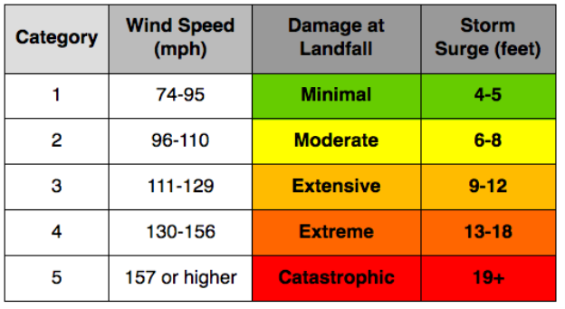
Category 1 hurricanes are associated with very dangerous winds that have the potential to produce some damage to the roofs of homes, large branches of trees may snap and extensive damage to power lines and poles is very likely resulting in power outages lasting from a few to several days.
Category 2 hurricanes are associated with extremely dangerous winds causing extensive damage to homes and toppling shallowly rooted trees. Extensive power outages are likely.
Category 3 hurricanes are associated with devastating damage. Well-built homes may have severe damage or removal of roofs. Many trees will be uprooted or snapped blocking many roads. Power and water may be unavailable for several days to weeks.
Category 4 hurricanes are associated with catastrophic damage. Homes and other buildings are likely to sustain severe damage with loss of most of the roof and/or some walls. Most trees will be uprooted or snapped and power poles downed. Power outages are likely to last for several weeks to months and most of the affected area will be uninhabitable for weeks or months.
Category 5 hurricanes are also associated with catastrophic damage and loss of life. A very large number of homes will be destroyed; most trees will be toppled and the affected area will be without power and uninhabitable for weeks to months after the hurricane has struck.
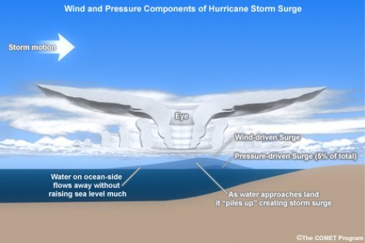
5. What is storm surge and how is it different from storm tide?
The storm surge is large dome of water that is higher than the surrounding ocean and is caused by water being pushed toward the shore by the force of the winds moving cyclonically around the storm (see Figure 4). The height of the storm surge is dependent on the storm intensity, the hurricane’s forward speed, the angel of approach to the coast and the shape of coastal features such as bays and estuaries.
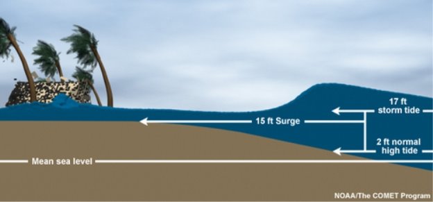
Storm surge should not be confused with storm tide, which is defined as the water level rise due to the combination of storm surge and the astronomical tide. This rise in water level can cause extreme flooding in coastal areas particularly when storm surge coincides with normal high tide, resulting in storm tides reaching up to 20 feet or more in some cases (see Figure 5).
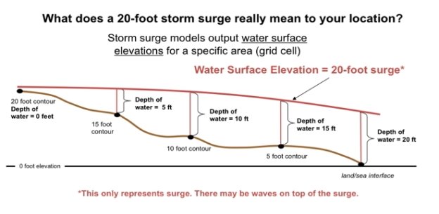
Storm surge "inundation" occurs when the storm surge floods coastal areas and refers to the height of the storm surge above the ground level. Figure 6 below demonstrates what a 20-foot storm surge means for your location. At the coast where height above sea level is zero, the water would be 20 feet above the ground, however, as you move inland the depth of the water becomes less and if you were 20 feet above sea-level, the height of the surge would be zero and you would not be affected by the storm surge. Therefore, it is critical to get to higher ground, i.e. higher than the expected storm surge, since most loss of life during hurricane strikes are due to drowning.
Are you prepared for the next disaster?
Disasters can strike at a moment’s notice. That’s why, at ContactRelief, we provide round the clock disaster monitoring to keep your operations ahead of disasters. With timely, comprehensive recommendations that are accurate to the ZIP code, ContactRelief ensures you focus less on the disaster, and more on your operations.
Contact sales@contactrelief.com for more information.