
Why don't hurricanes hit the West Coast of the USA?
ContactRelief Meteorologist Dr. Kevin Levey explains why the science behind the hurricane tracks.
Tuesday, 22 August 2017 09:00:00 -05:00
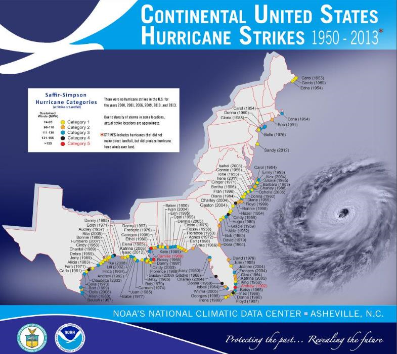
A question I always ask my university class when we first discuss hurricanes is why they think hurricanes always seem to strike the Gulf Coast or Eastern seaboard of the United states and not the West coast? Well, it all boils down to “Location, Location, Location”! If we look at Figure 1 you will observe all the land falling hurricanes that occurred between 1950 and 2013. What is striking is just how many have occurred along the Gulf Coast, Florida and the coasts of the Carolinas.
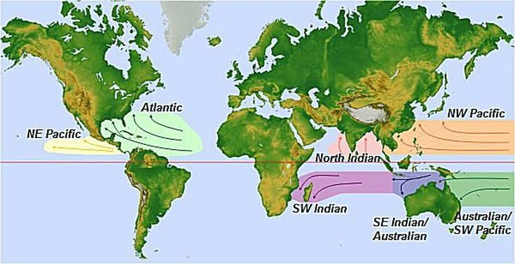
To answer the question as to why so many hurricanes tend to occur in the southern and eastern United States, we need to take a step back and look where the preferred locations of hurricanes are located around the world. Figure 2 shows the major hurricane regions of the world. You will observe that all the world’s hurricane regions are in the tropics. Another interesting feature to note is that the predominant wind in all these areas blows from the east to the west, i.e. “easterly” winds. The Atlantic hurricane region is much larger than the North-East Pacific Ocean region. So, in general, during the northern hemisphere summer, winds blow from Africa towards the United states in the tropical latitudes, i.e. generally between the equator and about 30° N.
If we look more closely at the Atlantic and NE Pacific hurricane basins and look at all recorded hurricane (tropical cyclone) tracks, we see a very distinct pattern as shown in Figure 3. The general pattern in the Atlantic hurricane basin appears to be a “C” shape in the Atlantic Ocean, but this is not the case in the NE Pacific hurricane basin. As mentioned previously, winds in the tropics south of about 30° N blow from the east towards the west. Thunderstorms that develop over West Africa often move out into the Atlantic Ocean and under the right atmospheric and oceanic conditions, will become a hurricane. These hurricanes then move from Africa, guided by the easterly winds, towards the west. As they move towards the Americas, they tend to curve towards the north, thanks to a force called the Coriolis force which is produced by the Earth spinning. Now, depending on the timing of the northward movement, some of the hurricanes may progress into the Caribbean region, the Gulf of Mexico or they may completely miss the United States.
It is clear from Figure 3 that many of the Atlantic hurricanes make landfall on the East Coast of the United States, however, few if any make landfall on the West Coast, i.e. California. Looking at the NE Pacific hurricane tracks, you will notice that the similar westward movement of hurricanes away from the coast of Mexico and Central America, but the biggest difference in this hurricane basin is the notable lack of hurricanes recurving back towards the United States. Why is that, you may ask? Another major player in determining the tracks of hurricanes is ocean temperature. Warm ocean temperatures, generally above 82° F or 28° C sustain hurricanes and allow them to grow stronger, while cooler sea surface temperatures will cause hurricanes to weaken and in most cases, die out. The biggest difference between the East and West coasts of the United States are the sea surface temperatures. The warm Gulf Stream flows northwards along the East Coast, while sea surface temperatures along the West Coast are significantly cooler and cannot sustain hurricanes.
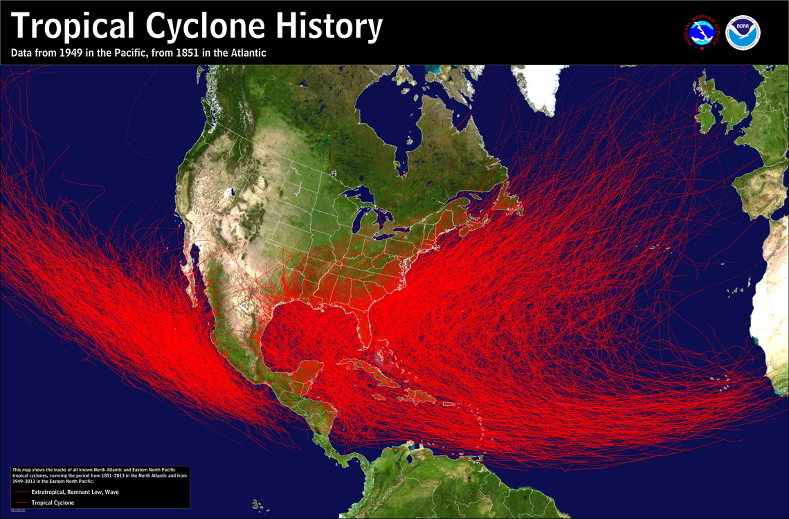
So, the distribution of the warm and cool ocean temperatures greatly influences the location and longevity of hurricanes. Hurricanes in the Atlantic Ocean are sustained by warm waters as they re-curve northwards, and often enhanced even further when they enter the very warm waters of the Gulf of Mexico, whereas, NE Pacific hurricanes have no such energy source as they move over colder waters of the Pacific Ocean and generally die out before they can re-curve back towards the Californian coast.
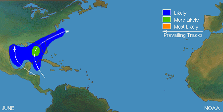
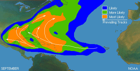
As the hurricane season progresses from early summer (June) to late summer (September, which is the peak of the hurricane season) so too, do the preferred locations of Atlantic hurricane formation. Since the Gulf of Mexico is generally a lot warmer than the Atlantic Ocean, one would expect hurricane formation to be more prevalent in the Gulf of Mexico in June and this is shown in Figure 4. However, by late summer when the Atlantic Ocean has had enough time to warm up, the area of likely hurricane formation expands greatly and includes the entire Gulf of Mexico, East Coast of the United States and the Caribbean stretching far eastwards towards the Azores off the coast of Africa as seen in Figure 5.
So, to conclude, the two driving forces that determine where hurricanes strike the United States are ocean temperatures and the prevailing easterly winds that drive hurricanes towards land, whereas, in the NE Pacific, hurricanes generally move away from land. And before I forget, yes, California has been struck by a category 1 hurricane back on 2nd October 1858 in San Diego, and one other time on 25th September 1939 in Long Beach, CA, by a Tropical Storm (a dying hurricane).
Get in touch
Shaping your outbound contact away from disaster stricken areas isn't just the right thing to do, it's smart business. To learn more about how ContactRelief can help you protect your brand, reduce your risk of adverse actions, and improve your contact center efficiency, click below to contact us.
Contact us