
Unusual Hurricane Intensification Down Under
Meteorologist Dr. Kevin Levey examines an Australian cyclone with unusual behavior.
Wednesday, 21 February 2018 08:30:00 -06:00
This past week Tropical Cyclone Kelvin made landfall as a category 1 hurricane over Northwestern Australia. Nothing too unusual about that, as northern Australia is frequently affected by hurricanes from both the Indian Ocean and the Pacific Ocean (where they are called tropical cyclones). However, what was unusual, was the intensification of the eye *after* it made landfall over northwestern Australia. This can be well seen in Figures 2 and 3 below.
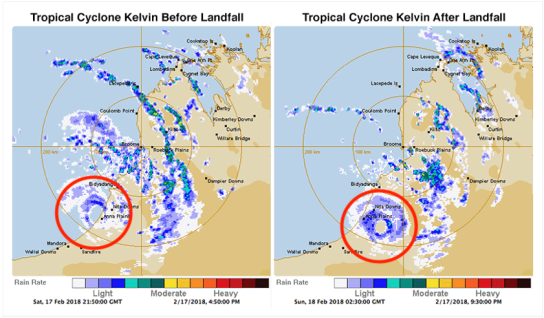
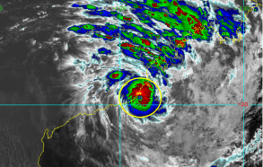
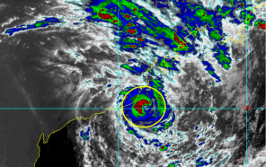
Typically, hurricanes rapidly weaken after making landfall. However, in this case, as seen in both the radar and satellite images above, there was clear intensification over land. Although rare in other parts of the world, this landfall intensification over northern Australia is not uncommon and is referred to the “Brown Ocean Effect”. Typically, a hurricane gains it energy from the condensation of water vapor which evaporates of very warm ocean surfaces. So, upon making landfall, it usually weakens immediately since the land is cooler, and offers much less water vapor. However, in northern Australia, the soil layer is quite deep and usually very hot. If good rains have occurred prior to the land-falling hurricane, then once the hurricane makes landfall, it often acts very much like a warm ocean surface allowing for continued intensification, as long as there is sufficient heat to allow for massive amounts of water vapor into the atmosphere. So there you go, I also learned something new this week!