Thunderstorms Explained
Meteorologist Dr. Kevin Levey examines the meteorology of thunderstorms.
Tuesday, 29 May 2018 04:00:00 -05:00
Last time I discussed the formation of thunderstorms and briefly touched on air mass thunderstorms. Often called “popcorn” convection, air mass or single-cell thunderstorms are small, brief, weak storms that grow and die within an hour or so. They are typically driven by heating on a summer afternoon. Single-cell storms may produce brief heavy rain and lightning.
So let’s look at some common thunderstorm terminology and what they mean.
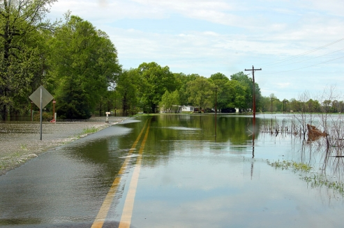
A multi-cell storm is a common, garden-variety thunderstorm in which new updrafts form along the leading edge of rain-cooled air (the gust front). Individual cells usually last 30 to 60 minutes, while the system as a whole may last for many hours. Multicell storms may produce hail, strong winds, brief tornadoes, and/or flooding as shown in Figure 1 below.
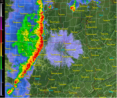
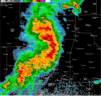
A squall line is a group of storms arranged in a line, often accompanied by “squalls” of high wind and heavy rain. Squall lines tend to pass quickly and are less prone to produce tornadoes than are supercells. They can be hundreds of miles long but are typically only 10 or 20 miles wide. Figure 2 below shows a typical squall line depicted on radar by the bright reds and oranges.
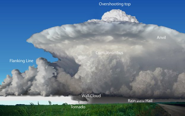
A supercell is a the most severe of all thunderstorms and generally last longer than 1 hour. The supercell thunderstorm is a highly organized storm consisting of an updraft (a rising current of air) that is tilted and rotating and a downdraft. This rotating updraft - as large as 10 miles in diameter and up to 50,000 feet tall - can be present as much as 20 to 60 minutes before a tornado forms. This rotation is called a mesocyclone when it is detected by Doppler radar. The tornado is a very small extension of this larger rotation. Most large and violent tornadoes come from supercells. Heavy rainfall and often hail falls to earth in the strong downdrafts which can also be very dangerous to aircraft. Very severe downdrafts are known as microbursts. Figure 3 below shows the typical features of a supercell thunderstorm.
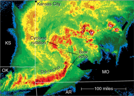
A bow echo is a radar signature of a special kind of squall line that “bows out” as winds blow from behind the line and circulations develop on either end. Figure 4 below shows a typical bow echo on radar. A strongly bowed echo may indicate high winds in the middle of the line, where the storms are moving forward most quickly. Brief tornadoes may occur on the leading edge of a bow echo. Often the north side of a bow echo becomes dominant over time, gradually evolving into a comma-shaped storm complex.
A Mesoscale Convective System (MCS) is a collection of thunderstorms that act as a single system. A MCS can spread across an entire state and last more than 12 hours. On radar one of these large weather phenomenon might appear as a solid line, a broken line, or a cluster of cells. This all-encompassing term can include any of the following storm types:
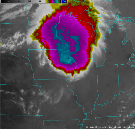
Mesoscale convective complex (MCC)—A particular type of MCS, a MCC is a large, circular, long-lived cluster of showers and thunderstorms identified by satellite. It often emerges out of other storm types during the late-night and early-morning hours. MCCs can cover an entire state as shown in Figure 5 below.
Mesoscale convective vortex (MCV)—A low-pressure center within a MCS that pulls winds into a circling pattern, or vortex. With a core only 30 to 60 miles wide and 1 to 3 miles deep, a MCV is often overlooked in standard weather analyses. But an MCV can take on a life of its own, persisting for up to 12 hours after its parent MCS has dissipated. This orphaned MCV will sometimes then become the seed of the next thunderstorm outbreak. An MCV that moves into tropical waters, such as the Gulf of Mexico, can serve as the nucleus for a tropical storm or hurricane.
A derecho is a widespread, long-lived wind storm that is associated with a band of rapidly moving showers or thunderstorms. Although a derecho can produce destruction similar to that of tornadoes, the damage typically is directed in one direction along a relatively straight path. As a result, the term “straight-line wind damage” sometimes is used to describe derecho damage. By definition, if the wind damage swath extends more than 240 miles and includes wind gusts of at least 58 mph or greater along most of its length, then the event may be classified as a derecho. Bow echoes discussed earlier can also be part of these derechos as shown in Figure 6 below:
In the next installment of Weather Insights, we will look at supercells and tornado formation in much more detail.