
June Climate Retrospective
Meteorologist Dr. Kevin Levey reviews the U.S. Climate in June 2018
Tuesday, 17 July 2018 06:23:00 -05:00
June 2018 was particular active as Figure 1 (below) shows. Many warm and dry and high temperature related climate anomalies and events occurred. Significant flash flooding and very heavy rain events also took their toll during June. These and other events of note during June 2018 will be discussed below.
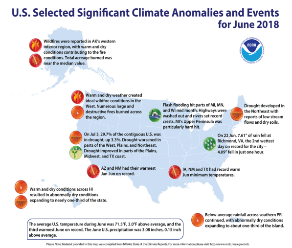
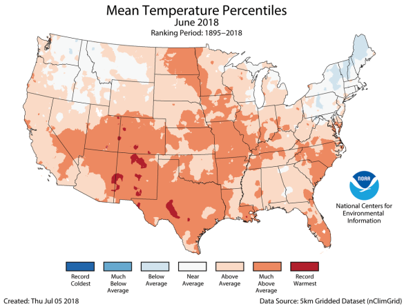
June 2018 mean average temperature for the contiguous U.S. was 71.5°F, 3.0°F above the 20th-century average. Only June 1933 and 2016 were warmer for the nation. Above-average temperatures spanned much of the Lower 48, with near- to below-average temperatures in the Northwest and Northeast. Figure 3 (below) shows the mean temperature percentiles for June 2018 and what is obvious from that figure are the following:
- Above-average June temperatures were observed for much of the nation, except for New England. Much-above-average temperatures were observed over seventeen states across parts of the Southwest, Great Plains, Midwest, and Southeast. Minimum temperatures were particularly warm across the central and southeastern U.S. Iowa, New Mexico and Texas each had a record warm June minimum temperatures.
- Near- to below-average June temperatures were observed across the Northwest and Northeast. In the Northeast, a heatwave that began in late June and persisted into early July was not enough to compensate for below-average temperatures in early- and mid-June.
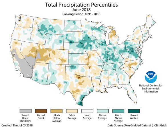
The June 2018 precipitation total for the contiguous U.S. was 3.08 inches, 0.15 inch above average, and ranked near the middle of the 124-year period of record, Much-above-average precipitation fell in parts of the Midwest, Northern to Central Plains and Mid-Atlantic with below-average precipitation across parts of the West and South (shown in Figure 3). Several significant flash-flooding events impacted the U.S. during June.
-
Above-average precipitation was observed in many states stretching from the Northern Rockies and Plains, through the Midwest, and into the mid-Atlantic. Indiana, Iowa, and Kentucky each had June precipitation totals that were much above average. During June, there were several noteworthy heavy precipitation events that caused significant regional flooding:
- On June 15-17, heavy rainfall caused fatal flash flooding in the Upper Midwest, washing out highways, with record crests along some rivers. One of the hardest hit communities was Houghton County, Michigan, where nearly 7.0 inches of precipitation fell in a short period.
- A slow moving low-pressure system, with tropical origins, dropped record-setting rainfall along the southern Texas coast between June 18th and the 21st. A report of 11.00 inches or more of precipitation near Premont, Texas, was received by the National Weather Service. The rain gauge reached its capacity of 11.00 inches before overflowing. Widespread flooding was reported during the event.
- On June 22, 7.61 inches of precipitation was observed in Richmond, Virginia, causing flash flooding, power outages and the closure of the Richmond International Airport. This was the second highest daily rainfall total for the city, with a period of record that dates to 1887. Of the total precipitation, 4.09 inches of rain fell in just one hour, a new hourly record for the airport.
- Below-average precipitation was observed across parts of the West, South, Midwest, Southeast, and Northeast during June. Utah tied its sixth driest June on record, receiving just 0.07 inch of precipitation during the month, 0.66 inches below average. Some locations in the Southwest received zero precipitation during June, a frequent occurrence during this time of year.
- According to the July 3 U.S. Drought Monitor report, 29.7 percent of the contiguous U.S. was in drought, up from 26.4 percent at the end of May. Drought conditions worsened in parts of the West, Southern Plains, the Mississippi River Valley and the Northeast. Numerous large wildfires impacted parts of the Rockies and Southwest during June, where months of warm and dry conditions contributed to an abundance of wildfire fuels. Drought conditions improved for parts of the Great Plains, Midwest, and the Texas Gulf Coast. Abnormally dry conditions expanded in Hawaii and Puerto Rico.
Tropical Outlook:
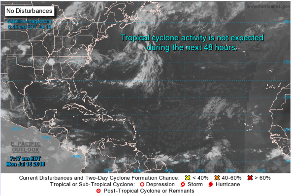
After an active period of storms across the Atlantic Ocean during the past week, conditions are now expected to remain quiet over the next seven days, with no tropical systems forecast to develop in the Gulf of Mexico over the course of the upcoming week (as seen in Figure 4). There is slight chance that an area of thunderstorms may undergo some tropical development over the far-southern Caribbean during the latter half of this week, however, this potential system would stay far to the south and would not be expected to enter the Gulf of Mexico at any point during its lifespan. No other tropical development is expected throughout the Atlantic basin during the next seven days.
Weekly Outlook:
Here is what to expect regarding precipitation and temperature in the coming week.
Figures 5 and 6 below show the expected 6-10-day temperature and precipitation outlooks. The colored shading on the map indicates the degree of confidence the forecaster has in the category indicated, where "B" and blue colors indicate "below-normal" and "A" and orange-red colors indicate "above normal". The darker the shading, the greater is the level of confidence. The numbers labeling the contours separating different shades gives the probability that the indicated category (A, B, or N) will occur.
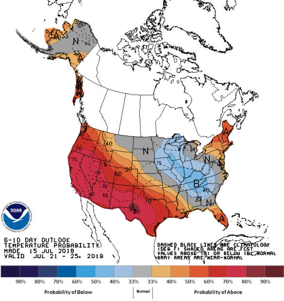
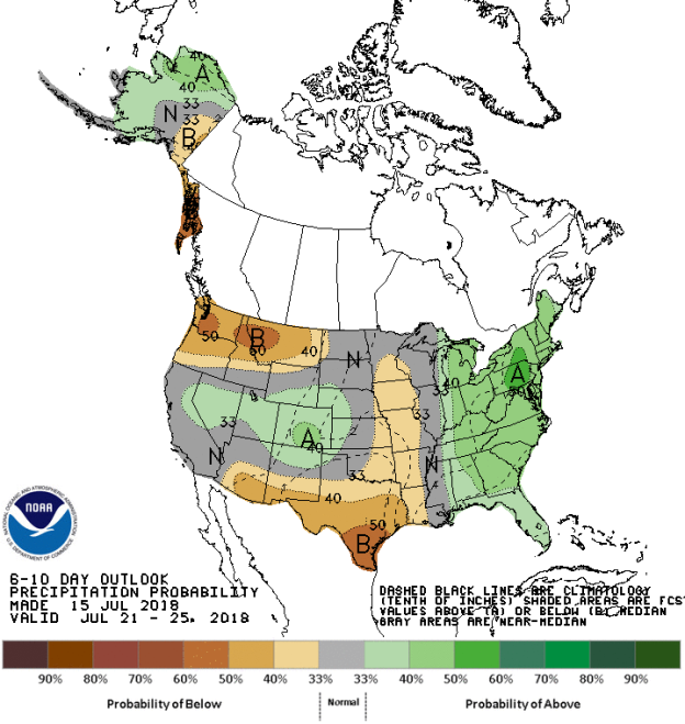
Generally, the probability of below average temperatures (as seen in Figure 5) is generally low over much of the Midwest (excluding Michigan, the northern Plains States, the western Ohio Valley, Tennessee, Kentucky and far northern Alabama and Georgia. In general, the probability is moderate to high that the entire western half of the country will experience above average temperatures, centered on the Desert Southwest, including areas as far east as Mississippi to the Pacific Northwest. Florida and New England should expect low to moderate probabilities of above average temperatures. Most of the Northern Tier states should experience normal temperature for this time of the year.
The precipitation outlook for the next 6-10 days (Figure 6) shows the probabilities are low to moderate for below average rainfall over much eastern Texas, eastern Oklahoma, eastern parts of the Plains states all the way into southern Minnesota. Probabilities for below average are moderate to high over the Pacific Northwest, northern Idaho, and Montana. Moderate probabilities for above average rainfall exists over western and northern Alaska and the entire eastern third of the USA. Much of Colorado, central Nevada and central Utah should also see a low to moderate probability for above average rainfall. Most of California the Dakotas, northern Minnesota, Wisconsin, and Illinois should experience average rainfall for this time of the year.
Weekly hazards output by the NWS’s Climate prediction center for the next 3-7 days is shown in Figure 7 below.
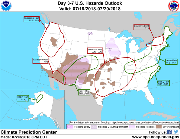
Figure 7 shows that most of the expected weather hazards over the United States in the next 3 to 7 days. The seasonal monsoon continues over Desert Southwest with heavy rains expected over eastern Arizona, Colorado, western New Mexico and parts of extreme western Kansas between the 16th and 17th July. Heavy rain should also be expected over a small part of Northwestern Alaska on the 19th July. Most of New England, the northern Mid-Atlantic states, Kentucky and Tennessee should expect heavy rains between the 16th and 17th July and between the 18th and 19th July over the coastal areas of the Carolinas. Excessive heat will occur over large parts of the county: on the 20th July over southeastern California and far southwestern Arizona; between the 16th and 19th July over much of far northern California, Oregon, most of Washington, western Idaho and northwestern Nevada; between the 16th and 18th July over much of the southern Mississippi River Valley, including southeastern Kansas, Missouri, Oklahoma, Arkansas, Louisiana and eastern and over northern New York, Vermont and New Hampshire on the 16th July.
