
Fall and Winter Precipitation Forecast
Meteorologist Dr. Kevin Levey tells us how much rain to expect this Fall and Winter in the US
Wednesday, 03 October 2018 06:00:00 -05:00
Tropical Outlook:
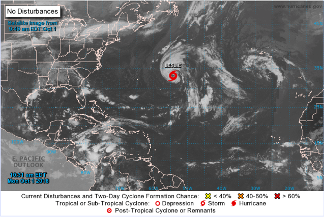
As we enter October, we are now moving away from the peak of the hurricane season, with tropical activity in the Atlantic now significantly reduced compared to the past few weeks (see Figure 1 below). Conditions throughout the Gulf of Mexico and along the East Coast are mostly quiet this morning. Tropical Storm Leslie, located in the north-central Atlantic, is currently the only active tropical system in the basin and is not expected to impact any land areas throughout the remainder of its lifespan. Looking ahead at the next seven days, a quiet week appears to be in store for the Gulf of Mexico and East Coast, as no tropical systems are forecast to develop in or enter either region. The only area of note throughout the week will be the central Caribbean Sea, where a broad area of disturbed weather is forecast to develop over the course of the next few days and could potentially undergo tropical development by the end of the week. However, development, if any, will be slow to occur and it is still far too early to say whether this potential system may have any impacts on the United States.
Looking ahead to this winter!
It’s that time of the year again as we look towards the winter and see what the climate models are predicting for the United States.
There are a number of climate models that try and predict the temperature and precipitation on a monthly basis for at least six months into the future. The North American Multi-Model Ensemble (NMME) is an experimental multi-model seasonal forecasting system consisting of coupled models from US modeling centers including NOAA/NCEP, NOAA/GFDL, IRI, NCAR, NASA, and Canada's CMC. Instead of just using one single model, the NMME is preferred since it is a combination of many climate models and yields better forecasts than any one single individual model. In today’s posting, I will only discuss the monthly precipitation outlooks and next week, we will look at the monthly temperature outlooks for the USA. The following maps show the expected monthly rainfall departures (in millimeters per day – 25.4mm = 1 inch).
The impact of the upcoming weak to moderate EL Niño is evident in the precipitation forecasts with drier conditions over the northern parts of the country and wetter conditions over the southern parts.
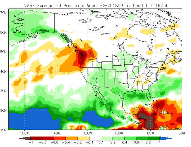
Figure 2 above shows that for October 2018, the Pacific Northwest should expect below average rainfall. Most of the southwestern areas, Texas and Florida can expect slightly above average rainfall. The remainder of the country should expect mostly average precipitation.
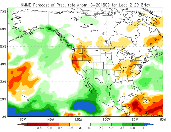
Figure 3 above, shows that much of the Pacific Northwest, Northern and Central California should expect below average rainfall. It is also expected to be slightly drier than normal over the much of the Tennessee River Valley and Ohio Valley. The southwestern areas of the United States should expect slightly above average rainfall. The remainder of the country should expect mostly average precipitation during November 2018.
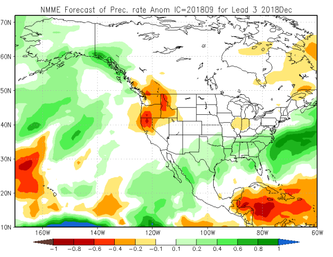
Figure 4 above, shows that December 2018 will be wetter than average over the southern parts of the Gulf coastal states, stretching from Texas into Florida and the Mid-Atlantic states like Virginia. Much of the Pacific Northwest, Central and Northern California will be drier than normal. A small part of northern Illinois and Indiana can also expect slightly drier than normal conditions. The remainder of the country should expect mostly average precipitation.
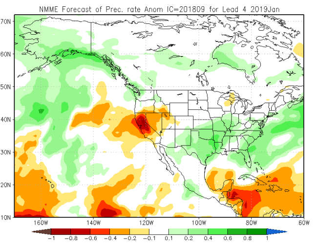
Figure 5 above, shows continued below average rainfall in January 2019 over California, Nevada and northern Utah, but especially Central and Northern California. Slightly below average rainfall may also occur over a small area of northern Wisconsin and the Upper Peninsula of Michigan.. Continued above average rainfall should be expected over much of the southern areas, including Texas, Florida and parts of the Southern and Central Plains states. The remainder of the country should experience mostly average precipitation during January 2018.
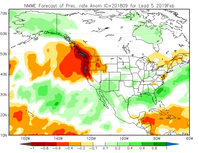
Figure 6 above, shows that during February 2019, the Pacific Northwest, Idaho and Northern and Central California can expect much below average rainfall, while the southern areas of California, Arizona and New Mexico, the southern areas of the Gulf States and Florida can expect above average precipitation. Northern New England should also expect drier than normal conditions. This pattern is typical of El Niña conditions. The remainder of the country should expect mostly average precipitation.
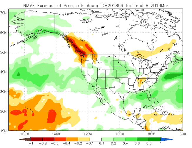
Finally, Figure 7 above, shows that although El Nino is expected to weaken during March 2019, it will continue to be dry over the Pacific Northwest and far northern U.P. of Michigan and parts of Tennessee and northern Mississippi, while above average precipitation will continue over Florida and the southern areas of California and Arizona and the Central and Northern Plains states and also over parts of the coastal areas of Central and Northern California. The rest of the country should expect average precipitation.
Weekly Outlook:
Here is what to expect regarding precipitation and temperature in the coming week.
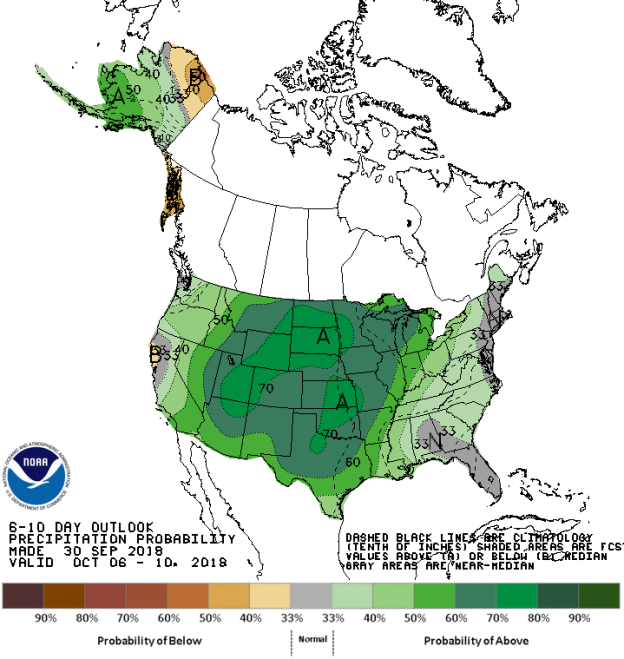
Figures 8 and 9 below show the expected 6-10-day temperature and precipitation outlooks. The colored shading on the map indicates the degree of confidence the forecaster has in the category indicated, where "B" and blue colors indicate "below-normal" and "A" and orange-red colors indicate "above normal". The darker the shading, the greater is the level of confidence. The numbers labeling the contours separating different shades gives the probability that the indicated category (A, B, or N) will occur.
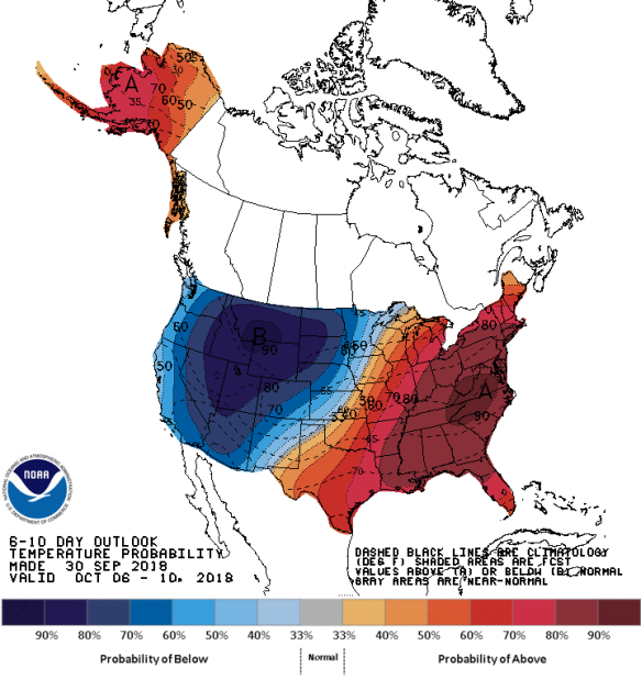
Generally, the probability of below average temperatures (as seen in Figure 8) is high to very high over much over the western half of the country, center over much of the Northern Rocky States and Northern tier states. In general, the probability is moderate to high that Alaska and the eastern half of the country will experience above average temperatures, centered on the mid-Atlantic. Almost no areas will experience normal temperatures for this time of the year.
The precipitation outlook for the next 6-10 days (Figure 9) shows the probabilities are low to moderate for below average rainfall over far northern Alaska the coastal areas of Northern California. Generally moderate to high probabilities for above average rainfall exists over the entire country, especially the Central and Northern Plains states, with lower probabilities of above average rainfall over the Pacific Northwest and much of the Eastern third of the country. Much of the coastal areas of the Mid-Atlantic and New England, Florida and parts of northern California should expect average rainfall for his time of the year.
Weekly hazards output by the NWS’s Climate prediction center for the next 3-7 days is shown in Figure 10 below.
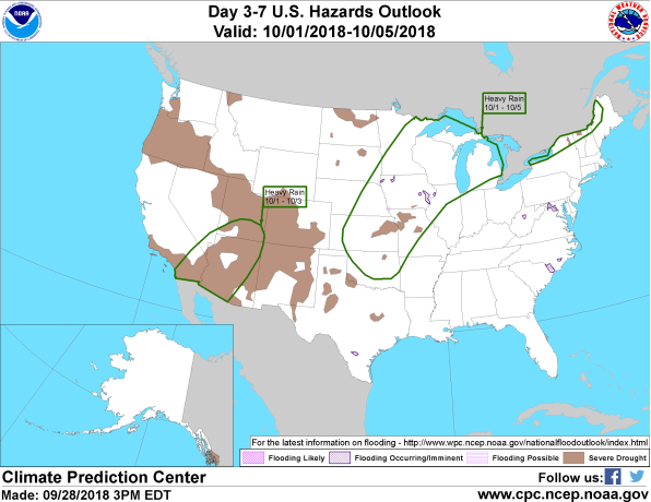
Figure 10 shows that most of the expected weather hazards over the United States in the next 3 to 7 days. Heavy rain is expected from the remnants of Hurricane Rosa over much of the southern areas of California, Arizona and southern Utah between the 1st and 3rd October. Heavy rain should also be expected over much of the northern Mississippi River Valley, the Midwest and far northern areas of New England between the 1st and 5th October.