Want to reach up to 5 times more contacts during a disaster?
Sign up for a free trial

Hurricane Michael Aiming at Florida Panhandle
Meteorologist Dr. Kevin Levey tells us what to expect fronm Hurricane Michael
Tuesday, 09 October 2018 07:15:00 -05:00
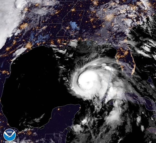
A significant hurricane threat has developed for the Gulf Coast during the middle of the week as Hurricane Michael, now advancing through the Gulf of Mexico (as seen in Figure 1 below), is forecast to make landfall as along the Florida panhandle sometime on Wednesday. Michael quickly strengthened starting early Sunday and maximum sustained winds are now at 90 mph with the storm currently moving towards the north at 12 mph.
STORM TRACK
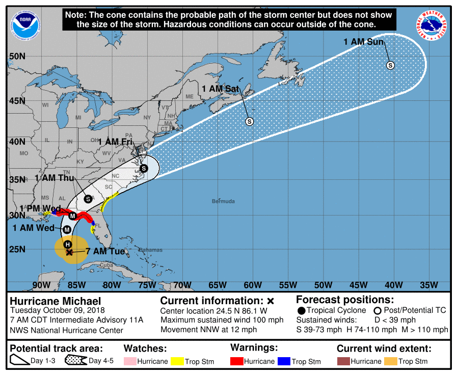
As seen in figure 2 above, Hurricane Michael will continue its general northward track today. By early Wednesday, Michael is forecast to begin turning towards the northeast while simultaneously picking up its forward speed as it approaches the western Gulf Coast, with that motion expected to continue up through landfall.
The vast majority of hurricane models are projecting Michael to make landfall along the Florida Panhandle some time on Wednesday afternoon, however the exact timing will largely depend on when the storm makes its turn towards the northeast. An earlier turn would mean a track closer towards the Big Bend region of Florida, with landfall on Wednesday night or even extremely early Thursday morning. Although less likely, a later turn to the Northeast would likely take Michael towards the direction of Pensacola and Panama City, Florida, with a landfall timing of Wednesday morning or early afternoon.
INTENSITY
Michael will continue to strengthen over the next 24 hours as it traverses the Gulf of Mexico. Michael is likely to go through its most pronounced period of intensification during this time period, with most hurricane models projecting the storm to attain category 3 status by Wednesday. After this period, conditions for hurricane development are expected to become less favorable meaning the storm's intensity is likely to level off or decrease slightly before landfall.
It is too early to say with any confidence what Michael's exact intensity will be when it comes ashore later on Wednesday although forecasters at the National Hurricane Center show the storm approaching landfall as a category 3 hurricane. Michael's intensity will largely depend on its exact track, as a more eastward track towards the Big Bend region would be more likely to result in a minimal hurricane landfall, while a further westward track towards the western Panhandle would be much more likely to result in a major hurricane landfall.
POTENTIAL IMPACTS
While the exact severity and location of Michael's impacts are still uncertain, it is safe to say that the storm will bring dangerous conditions to much of the western Gulf Coast later this week
Dangerous wind conditions are currently forecast to begin early Wednesday along the Florida Panhandle and persist throughout the day. While the severity of the wind impacts will largely depend on Michael's intensity at landfall, at minimum the winds will likely be capable of causing the widespread downing of trees and power lines along the western Gulf Coast, which would potentially result in several-day power outages.
It is still too early to say what Michael's storm surge impacts will be. Generally speaking, the further west Michael tracks, the more likely that the storm will be capable of bringing a dangerous storm surge to the Florida coastline.
What can be said already be said with near certainty is that Michael will bring widespread heavy rainfall to the majority of the western Gulf Coast and inland areas of the eastern Southeast during the latter half of the week. Early model projections are showing the Michael will be capable of producing at least 10 inches of rainfall along the coastline as it makes landfall, which would result in extensive inland flooding throughout the impacted areas of the Southeast. As Michael's future track becomes more refined over the next 48 hours, the exact location of the heaviest rainfall amounts will become much clearer. Hurricane Michael's overall potential impacts will become much clearer over the next two days as it goes through its largest window of potential intensification
Weekly Outlook:
Here is what to expect regarding precipitation and temperature in the coming week.
Figures 3 and 4 below show the expected 6-10-day temperature and precipitation outlooks. The colored shading on the map indicates the degree of confidence the forecaster has in the category indicated, where "B" and blue colors indicate "below-normal" and "A" and orange-red colors indicate "above normal". The darker the shading, the greater is the level of confidence. The numbers labeling the contours separating different shades gives the probability that the indicated category (A, B, or N) will occur.
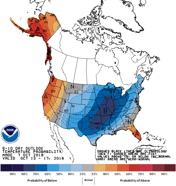
Generally, the probability of below average temperatures (as seen in Figure 3) is high over much over the eastern half of the country, center over southern Plains states, stretching northeastwards into the Midwest and Ohio Valley. In general, the probability is moderate that Alaska, Florida and the West Coast states will experience above average temperatures. Montana and parts of the Southeast will experience normal temperatures for this time of the year.
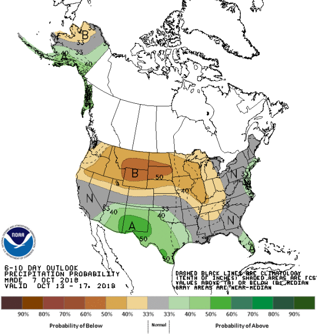
The precipitation outlook for the next 6-10 days (Figure 4) shows the probabilities are low to moderate for below average rainfall over the northern half of the country from far northern California, the Pacific Northwest eastwards to the Midwest and stretching southwards to as far as northern Alabama and Mississippi. Generally, moderate probabilities for above average rainfall exists over Arizona, New Mexico and much of Texas, southern Florida and the coastal areas of the Mid-Atlantic States. Remaining areas should expect average rainfall for his time of the year.
Weekly hazards output by the NWS’s Climate prediction center for the next 3-7 days is shown in Figure 5 below.
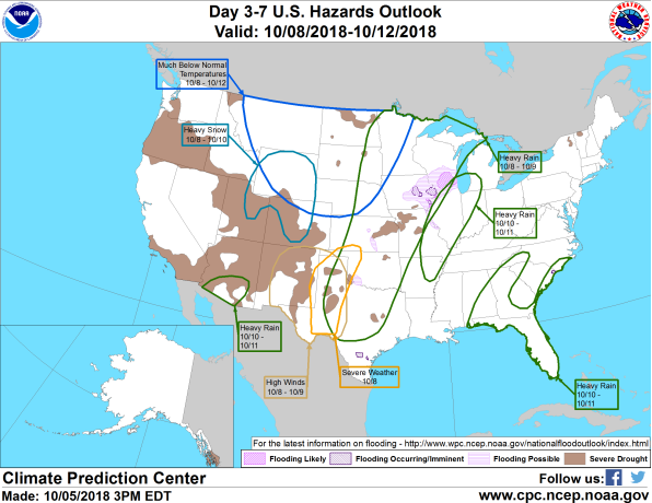
Figure 5 shows that most of the expected weather hazards over the United States in the next 3 to 7 days. Heavy rain is expected from Hurricane Michael over much of the southeastern areas of the United States, including Florida, southeastern Alabama, most of western Georgia and the coastal areas of the Carolinas between the 10th and 11th October. Heavy rain should also be expected over much of the northern Mississippi River Valley between the 10th and 11th October. Heavy rains are expected over a wide area of the central USA stretching from Texas, through the Plains States into the Midwest and Minnesota between the 8th and 9th October. Heavy rain should also be expected over southern Arizona between the 10th and 11th October. Severe weather is expected over western Texas on the 8th October. High winds are expected over much of New Mexico and western Texas between the 8th and 9th October. Much below average temperatures are expected over much of the Northern Tier States and the northern Plains States between the 8th and 12th October. Heavy snow should be expected over the northern areas of Utah and Colorado and all of Wyoming between the 8th and 10th October.