Weekend of Tornadoes
9 dead and dozens injured in weekend tornado outbreak
Tuesday, 16 April 2019 08:54:00 -05:00
This past weekend saw an outbreak of severe weather accompanied by many tornadoes and severe thunderstorms from Texas to the East Coast, leaving at least eight people dead, dozens injured, and close to 100 homes destroyed. Three deaths were attributed to tornadoes, while five others were caused by falling trees, floodwaters and a storm-related traffic accident.
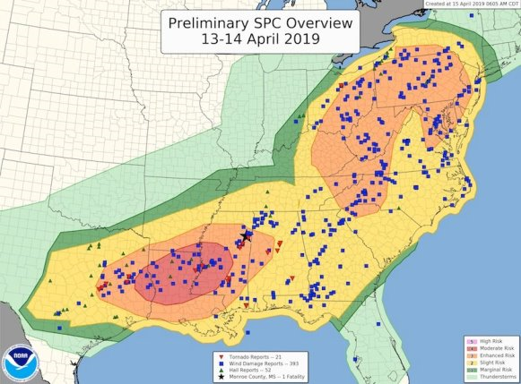
As of late this morning, the NOAA/NWS Storm Prediction Center had compiled 38 tornado reports, 70 reports of severe hail (at least 1” in diameter), and 590 reports of severe wind gusts (at least 58 mph) for the period from 7 am CDT Saturday to 7 am CDT Monday. The number of confirmed tornadoes may end up lower than 38, as multiple reports can occur from the same tornado. The outbreak was well captured by SPC's risk areas issued on Saturday and Sunday, as shown in Figure 2 (below).
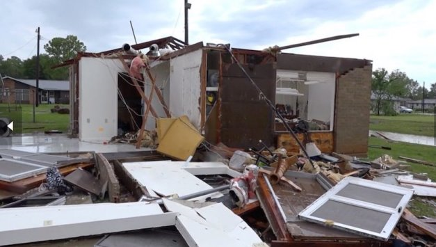
At the start of the weekend, an intensifying surface low pulled rich Gulf moisture across eastern Texas underneath a strong upper-level low causing the most destructive tornadoes. Based on preliminary storm surveys, one tornado brought damage preliminarily estimated as EF3 with peak winds of 140 mph to the Texas town of Franklin. According to KTBX, the twister destroyed 55 homes, a church, 4 businesses, a duplex and part of the local housing authority building.
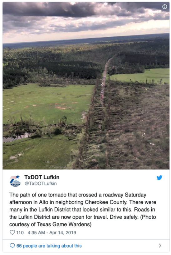
Further to the northeast, two tornadoes, one rated as an EF2 by the National Weather Service, and the second an EF3, struck the unfortunate town of Alto. In the forested countryside, large swaths of trees were destroyed (See Figure 3 below)
Several tornadoes struck near Vicksburg, Mississippi, on Saturday evening, including two rated at EF2, and several more twisters developed late Saturday night and early Sunday morning as supercells embedded in squall lines raced north across Mississippi and Alabama. The hardest-hit town was Hamilton, MS, where several people were injured, and a 95-year-old man was killed in his manufactured home. Thousands of students at Mississippi State University took shelter as an EF1 tornado moved through Starkville; no injuries were reported.
Counting the three tornado-related deaths this past weekend, tornadoes have taken 27 lives this year as of Sunday, April 14. In the entire year of 2018, only 10 people were killed by twisters, a record low in data going back to the 1800s. However, by this date in 2017, a total of 28 people had been killed by tornadoes, mainly due to deadly outbreaks in both January and February of that year.
Despite the small number of tornadoes, Sunday was the year's most active day thus far for severe weather overall.
Unfortunately, another multi-day outbreak of severe weather is in the cards this week for the central and eastern U.S., as an amplified jet stream and a highly progressive, dynamic weather pattern continues to play out across North America. Widespread severe weather, including a risk of tornadoes, is expected to develop from Texas to Iowa on Wednesday. Giant hailstones may pummel parts of the region, especially across the enhanced-risk area in Oklahoma and Texas. This north-south belt of severe weather will cross the Mississippi on Thursday and reach the coastal Southeast and mid-Atlantic by Friday.
Weekly Outlook:
Here is what to expect regarding precipitation and temperature in the coming week.
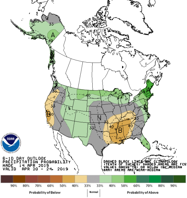
Figures 4 and 5 below show the expected 6-10-day temperature and precipitation outlooks. The colored shading on the map indicates the degree of confidence the forecaster has in the category indicated, where "B" and blue colors indicate "below-normal" and "A" and orange-red colors indicate "above normal". The darker the shading, the greater is the level of confidence. The numbers labeling the contours separating different shades gives the probability that the indicated category (A, B, or N) will occur.

Generally, the probability of below average temperatures (as seen in Figure 4) is low over the coastal areas of the Gulf Coast states, including the northern half of Florida, and also over Washington and the northeastern and southeastern areas of Alaska. Probabilities for above average temperatures are moderate to high, mainly over New England and the Mid-Atlantic, and over northern Texas, the Central Plains states, with lower probabilities over much of the western half of the country and far western Alaska. The far northern areas of the USA and the Tennessee River Valley will experience normal temperatures for this time of the year.
The precipitation outlook for the next 6-10 days (Figure 5) shows a low probability of belowaverage rainfall over much of California and western Oregon and most of the southern Mississippi River Valley including much of Arkansas, Tennessee, Mississippi, Alabama and Louisiana. A low to moderate chance of above average precipitation is expected over the far northern areas of the USA, southern Florida and most of southern Alaska, with slightly higher probabilities for above average rainfall over New England. Remaining areas will experience average precipitation for this time of the year.
Weekly hazards output by the NWS’s Climate prediction center for the next 3-7 days is shown in Figure 6 below.
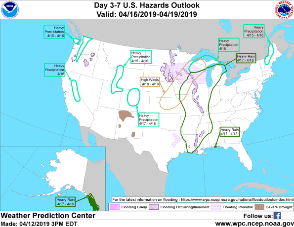
Figure 6 shows that most of the expected weather hazards over the United States in the next 3 to 7 days. Heavy rain is expected over the far western panhandle of Florida and most of the Mississippi River Valley from Louisiana northwards into the Midwest between the 17th and 18th April. Heavy rain is also expected over far southeastern Alaska between the 17th and 19th April. Heavy precipitation is expected over: Central Californian on the 16th April; northern and northwestern Washington between the 15th and 16th April; far western Wyoming and northeastern Utah between the 15th and 16th April; over northern Wisconsin and the U.P. of Michigan on the 18th April and finally, over the western areas of Maine and northern New Hampshire between the 15th and 16th April. High winds can be expected over a large area stretching from eastern Kansas, southeastern Nebraska northeastwards into the U.P. of Michigan between the 18th and 19th April. Flooding is either currently occurring or imminent over much of the Mississippi River, large areas of eastern South Dakota, far eastern North Dakota, northern areas of Iowa, the southern half of Minnesota and almost all of Wisconsin. Flooding is possible over the eastern interior of Oregon.
Protect your brand AND revenue when disaster strikes.
Try ContactRelief FREE for 30 days. Discover how we can help you reach up to 5x more customers in a disaster zone – while protecting your brand image.
Start free trial